Maps - Worksheets
CBSE Worksheet 01
Ch-15 Map
- Which of the following is not the component of the map?
i. Distance
ii. Direction
iii. Globe
iv. Index
v. Sketch- III, II, IV
- I, II, III, IV, V
- II, III, V
- II, III, IV
- A sketch is a ________ mainly based on memory and not to the ________.
- Plan, Map
- Plan, Scale
- Drawing, Scale
- Scale, Map
- The bottom side of the map usually indicates ________ direction.
- North
- West
- South
- East
- ________ are large scale maps which are based on an actual survey of a small area.
- Political map
- Thematic map
- Cadastral map
- Topographical map
- Usually, left side of the map indicates ________.
- East
- West
- South
- North
- Match the columns:
Column A Column B (i) Small Scale Map (a) Guide Maps (ii) Large Scale Map (b) Roads and Railways (iii) Physical Map (c) Wall Maps and Atlas (iv) Thematic Map (d) Mountains and Mines - Fill in the blanks:
- Plainland is used for________ .
- ________ is a representation of earth on a flat surface according to scale.
- Railway lines, roads, boundaries are examples of ________.
- The direction on a map is concerning to __________ direction.
- State true or false:
- Maps showing the distribution of rice, sugarcane, and wheat, etc. are known as Thematic maps.
- A scale is necessary for a sketch.
- A compass is an instrument used to find out the speed of travelling.
- Large scale maps give more information than small scale maps.
- What do you mean by a thematic map?
- What are the different kinds of maps?
- What are conventional symbols in a map? How colours play an important role?
- Give the importance of sketch at a particular place. Give an example.
- What are the cardinal points and intermediate directions?
- What does a map scale show?
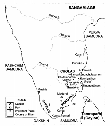
- On an outline map of India, show Southern kingdoms.
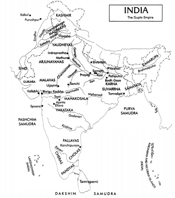
- On an outline map of India, mark the extent of the Gupta Empire.
CBSE Worksheet 01
Ch-15 Map
Solution
- (d) II, III, IV
Explanation: There are three Components of Maps – distance, direction and symbol. The following are not among the features of the map:
iii. Globe
iv. Index
v. Sketch - (c) Drawing, Scale
Explanation: A sketch is a drawing mainly based on memory and spot observation and not to scale. Sometimes a rough drawing is required of an area to tell where a particular place is located with respect to other places. - (c) South
Explanation: There are four directions, North, South, East and West. They are called cardinal points. The top of the map indicates North, down is South, to the left is West and to the right is East direction. - (d) Topographical map
Explanation: In modern mapping, a topographic map is a type of map characterized by large-scale detail and quantitative representation of relief, usually using contour lines, but historically using a variety of methods. - (b) West
Explanation: Usually at the top of the map is North, to the down is South, to the left is West and to the right is East. - (a) - (iii), (b) - (i), (c) - (iv), (d) - (ii).
- Agriculture
- Map
- Conventional symbols
- North
- True
- False, A scale is necessary for a map.
- False, compass is used to find out the main direction.
- True
- A map that gives focus on specific information is known as a thematic map. For example, road maps, maps showing the distribution of industries, etc.
- The different kinds of maps are as follows:
- Political maps.
- Physical maps.
- Thematic maps.
- Some symbols have a fixed meaning and are understood uniformally throughout the world. Such symbols are known as conventional symbols.
Colours play an important role in the conventional symbols like Blue for water bodies, Green for grasslands, Brown for hills, Yellow for deserts, etc. settlements, huts and buildings are shown in red. It is also used for different features like roads, bridges, markets, school, etc. - A sketch is a drawing mainly based on memory and spot observations and to scale. A rough drawing is mainly used for an area to tell of a particular place. Like to locate our friend’s house we use a rough sketch.
- The four major directions—North, South, East and West are called cardinal points. Besides these major directions, we have four intermediate directions—North-east (NE), South-east (SE), South-west (SW) and North-west (NW). The intermediate directions are very helpful in locating any place more accurately.
- Scale is the ratio between the actual distance on the ground and the distance shown on the map. For example, the distance between your school and your home is 10 km. If you show this 10 km. distance by 2 cm on a map, it means, 1 cm on the map will show 5 km. on the ground. The scale of your drawing will be 1cm = 5 km. Thus, the scale is very important in any map. Scale is important to calculate the distance between any two places on a map.