Physical Features of India -Test Papers
CBSE TEST PAPER-01
Class –IX Social Science (Physical Features of India)
General Instruction:
- All questions are compulsory.
- Question No. 1 to 4 carry one mark each.
- Question No. 5 to 10 carry three marks each.
- Question No. 11 and 12 carry five marks each.
- Which continents of today were parts of Gondwana Land?
- Which plateau lies between the Aravali and the Vindhya range?
- Name the island group of India having coral origin?
- Name highest peak of Western Ghats.
- Explain the three types of plate movements.
- The land of India displays great physical variation. Explain.
- Write a short note on Himadri.
- Write a short note on Himachal.
- Write a short note on Shiwaliks.
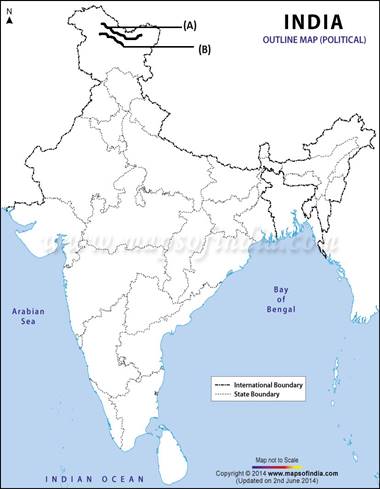
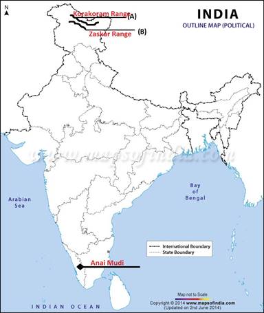
- Two features A and B are marked in the given political map of India. Identify these features with the help of the following information and write their correct names on the lines marked on the map.
- A Mountain Range
- A Mountain Range
On the same political map locate and label the following - Anai Mudi
- What are the features of Himalayan Mountains?
- Classify Himalayas on the basis of regions from east to west.
CBSE TEST PAPER-01
Class –IX Social Science (Physical Features of India)
[ANSWERS]
- India, Australia, South America and South Americaare the continents of today were parts of Gondwana Land.
- Malwa Plateau is the plateau which lies between the Aravali and the Vindhya range
- Lakshadweep is the island group of India having coral origin.
- Anai Mudi is the highest peak of western Ghats.
- The three types of plate boundaries are Convergent, Divergent and Transform.
i. The convergent plate boundary is when two plates move towards each other.
ii. The divergent plate boundary is when two plates move away from each other. This type of plate boundaries happens between the same plate type come towards each other.
iii. In the event of two plates coming together they may either collide and crumble, or one may slide under the other.The two plates slide along each other horizontally to form transform plate boundary. - The physiography of India shows huge variations:
i. The Peninsular Plateau is the ancient landmass and is composed of igneous and metamorphic rocks with gently rising hills and wide valleys..
ii. The Himalayas is a recent formation geologically. The whole mountain system of Himalaya represents a very youthful topography with high peaks, deep valleys and fast flowing rivers.
iii. The Northern Plains is the most recent landform and are made up of alluvial deposits.
iv. The Indian desert is located in the western part of the country covering the states of Gujarat and Rajasthan.
v. The Coastal Plains are a strip of land on the either side of the peninsular plateau between the Arabian Sea and the Western Ghats and Bay of Bengal and the Eastern Ghats in the west and east respectively.
vi. The Lakshadweep and the Andaman and Nicobar Islands comprises the islands of Indian mainland. - The Himalaya consists of three parallel ranges in its longitudinal extent. The northern most range is known as the Great or Inner Himalayas or the ‘Himadri’. It is the most continuous range consisting of the loftiest peaks with an average height of 6,000 metres. It contains all the prominent Himalayan peaks.The core of this part of Himalayas is composed of granite. It is perennially snow bound, and a number of glaciers descend from this range.
- The zone lying to the south of the Himadri forms the most rugged mountains system which is known as Himachal or Lesser Himalayas.The altitude of peaks in this range varies from 3,700 m to 4,500 m. Average width of this range is 50 km. This range is mainly composed of highly compressed and altered rocks. The Pir Panjal range, the Dhaula Dhar and the Mahabharat ranges are its prominent ranges. The famous valley of Kashmir, the Kangra and Kullu Valley in Himachal Pradesh are the part of Lesser Himalayas. This region is well known for its hill stations.
- The outer most range of the Himalayas is called the Shiwaliks. They extend over a width of 10-50 Km and have an altitude varying between 900 and 1100 metres. These ranges are composed of unconsolidated sediments.These valleys are covered with thick gravel and alluvium. The longitudinal valleys lying between the Himachal and Shiwaliks are called ‘Dun’.
- The Himalayas, geologically young and structurally fold mountains stretch over the northern borders of India.
i. These mountain ranges run in a west east direction the Indus to Brahmaputra.
ii. The Himalayas represent the loftiest and one of the most rugged mountains barriers of the world.
iii. They form an arc which covers a distance of about 2400 km.
iv. There width varies from 400 km in Kashmir to 150 km in Arunachal Pradesh.
v. The Himalayas consist of three parallel ranges in its longitudinal extent. Those are Himadri, Himachal and Shiwaliks. - The part of Himalayas lying between Indus and Sutlej has been traditionally known as Punjab Himalayas. But it is also known regionally as Kashmir and Himachal Himalaya from west to east.
- The part of Himalayas lying between Sutlej and Kali River is known as Kumaon Himalayas.
- The Kali and the Tista rivers demarcated the Nepal Himalayas.
- The part between Tista and Dihang rivers is called Assam Himalayas.
- The eastern most boundaries of the Himalayas are demarcated by Brahmaputra. Beyond Dihang gorge the Himalayas bend sharply to the south and spread along eastern boundary of India. They are called Purvanchal.
