Drainage - Test Papers
CBSE TEST PAPER-01
Class –IX Social Science (Drainage)
General Instruction:
- All Questions are Compulsory.
- Question No. 1 to 4 carry one mark each.
- Question No. 5 and 10 carry three marks each.
- Question No. 11 and 12 carry five marks each.
- Name any two peninsular rivers.
- Name the rivers that formed Sundarban Delta.
- What is the source of river Narmada?
- Which river has a braided channel in its entire length?
- Write a short note on Sunderban Delta.
- What is Drainage and drainage basin?
- Explain Water Divide with an example.
- From where does the Ganga originate and name the tributaries of Ganga River.
- From where does the river Brahmaputra originate and name the tributaries of Brahmaputra River.
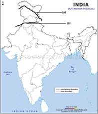
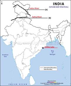
- Two features A and B are marked in the given political map of India. Identify these features with the help of the following information and write their correct names on the lines marked on the map.
- A west flowing river
- A river on which the world’s highest gravity dam is built On the same political map locate and label the following
- Chilka Lake
- Describe the role of rivers in the economic development.
- What are the importances of Lakes?
CBSE TEST PAPER-01
Class –IX Social Science (Drainage)
[ANSWERS]
- Krishna and Godavari
- Ganga and Brahmaputra
- Amarkantak hills
- Brahmaputra
- The Sunderban Delta is the worlds’ largest and the fastest growing delta.
- The Sunderban Delta derived its name the Sundari tree which grows well in marshland.
- It is the largest delta in India formed by Ganga, Brahmaputra, and Meghna rivers.
- The region is deeply covered by mangrove forest and is the home for Royal Bengal Tiger.
- The term drainage means the river system of an area. It is a system of flowing water from the higher level to lower level.
- Some small streams flowing from different directions come together to form the main river, which ultimately drains into a large water body.
- The area drained by a single river system is called a drainage basin.
- Water Divide is an elevated area or uplands which separate two drainage basins.
- Such uplands or elevated areas are known as Water Divide.
- ‘Ambala’ is located at the water divide between the Indus and Ganga River.
- It does not receive water from either of the two rivers.
- Bhagirathi is the headwater of Ganga which is fed by the Gangotri Glacier. It is joined by the Alaknanda at Deveprayag in Uttarakhand.
- The Ganga emerges from mountains on to the plains at Haridwar.
- The Ganga is joined by many tributaries from the Himalayas including major rivers such as the Yamuna, the Kosi, the Ghaghara, and Gandak.
- The Chambal, the Betwa, and the Son are the main tributaries coming from the peninsular uplands
- The Brahmaputra originates in Tibet east of Mansarowar Lake very close to the sources of the Indus and the Satluj.
- It is joined by many tributaries including the Dibang, the Lohit, the Kenula to form the Brahmaputra in Assam.
- The areas along the banks of rivers have witnessed great cultural and economic progress since ancient times. Rivers are an integral part of our folklore and folk songs.
- Water from the rivers is basic natural resource, essential for human, agricultural and industrial activities.
- Rivers and their associated alluvial soils provide the most productive agricultural lands of the country. Irrigation and generation of hydraulic energy from rivers have been a backbone of the development of an economy.
- Estuaries near the seashores where sweet water mixes freshly with the salty water of ocean have proved one of the most biologically productive areas of the world.
- Rivers provide primary channels of inland transportation, not only directly in the form of navigable waterways.
- Lakes are the best available fresh water source on the earth's surface.
- Lakes help to regulate the flow of water.
- During heavy rainfall it prevents flooding and during the dry season, it helps to maintain an even flow of water.
- Lakes can also be used for developing hydel power.
- Lakes are a valuable source of water.
- Lakes moderate the climate of the surrounding, maintain the aquatic ecosystem, enhance natural beauty, fishing, helps to develop tourism and provide recreation.
- Some lakes are also important tourist spots eg. Dai lake etc.
