Map Scale - Solutions
CBSE Class 11 Geography
NCERT Solutions
Chapter 25
Map Scale
1. Choose the right answer from the four alternatives given below:
(i) Which one of the following methods of scale is a universal method?
(a) Simple Statement
(b) Representative Fraction
(c) Graphical Scale
(d) None of the above
Ans. (b) Representative Fraction. A map scale in which figures representing units, like centimetres, inches or feet, are expressed in form of fraction example: 1:250,000
(ii) Map distance in a scale is also known as:
(a) Numerator
(b) Denominator
(c) Statement of Scale
(d) Representative Fraction
Ans. (a) Numerator. The numerator in scale indicates the relationship of distance measured on a map and the corresponding distance on the ground.
(iii) 'Numerator' in scale represents:
(a) Ground distance
(b) Map distance
(c) Both the distances
(d) None of the above
Ans. (a) Ground Distance
2. Answer the following questions in about 30 words:
(i) What are the two different systems of measurement?
Ans. The metric system of measurement is an internationally agreed decimal system of measurement. Kilometre, metre, centimetre etc. are used to measure the linear distances between two points on the ground. It is referred to as the Metric System of Measurement and presently used in India and many other countries of the world.
Another units which are used are miles, furlongs, yards, feet, etc. These are two different systems of measurement of the distances used in different countries of the world. It is known as the English System of Measurement and is prevalent in both the United States and the United Kingdom. India also used this system for measuring/showing linear distances
before 1957.English units are the historical units of measurement used in England up to 1826.
(ii) Give one example each of statement of scale in Metric and English system.
Ans. Metric System of Measurement
1 km = 1000 Metres
1 Metre = 100 Centimetres
1 Centimetre = 10 Millimetres
English System of Measurement
1 Mile = 8 Furlongs
1 Furlong = 220 Yards
1 Yard = 3 feet
1 Foot = 12 Inches.
(iii) Why is the Representative Fraction method called a Universal method?
Ans. The Representative Fraction method is called a Universal method because of its usefulness on the global scale. It can be used in all countries and is also termed as International Scale. The representative fraction method is called universal for the following reasons also:
(a) It shows the relationship between the map distance and the corresponding ground distance in units of length.
(b) The use of units to express the scale makes it the most versatile method.
(c) R. F. is generally shown in fraction because it shows how much the real world is reduced to fit on the map.
(d) For example, a fraction of 1 : 2,50,000 shows that one unit of length on the map represents 2,50,000 of the same units on the ground i.e. one mm, one cm or one inch on the map representing 2,50,000 mm, 2,50,000 cm and 2,50,000 inches, respectively of the ground.
(e) While converting the fraction of units into Metric or English systems, units in centimetre or inch are normally used by convention. This quality of expressing scale in units in R. F. makes it a universally acceptable and usable method.
(iv) What are the major advantages of the graphical method?
Ans. Graphs are powerful data evaluation tools. They provide quick visual summaries of essential data characteristics. This type of scale shows map distances and the corresponding ground distances using a line bar with primary and secondary divisions marked on it. This is referred to as the graphical scale or bar scale.
Advantages:
(a) It can express scale not only in kilometres and metres but the readings may also be shown in miles and furlongs.
(b) Unlike the statement of the scale method, the graphical scale stands valid even when the map is reduced or enlarged. This is the unique advantage of the graphical method of the map scale.
(c) It makes the data more easy to understand.
(d) It easily highlights the theme of the report. This helps to avoid wastage of time.
(e) Business executives can view the graphs at a glance and can make decision very quickly which is hardly possible through descriptive report.
3. Convert the given Statement of Scale into Representative Fraction (R. F.).
(i) 5 cm represents 10 km
Ans. Representative Fraction
Distance on Map = 5 cm
Distance on Ground = 10 km
Representative Fraction
Therefore representative fraction = 1 : 2,00,000 cm
(ii) 2 inches represents 4 miles
Ans. Representative Fraction
2 inches = 4 miles
therefore, 1 inch= 2 miles (63,360 x 2)
1 inch on map = 1,26, 720 inches on ground.
Therefore representative fraction = 1 : 1, 26, 720
(iii) 1 inch represents 1 yard
Ans. Representative Fraction
Distance on Map = 1 inch
Distance on Ground = 1 yard
1 yard = 36 inches
Representative Fraction
Therefore representative fraction = 1:36
(iv) 1 cm represents 100 metres
Ans. Representative Fraction
Distance on Map = 1 cm
Distance on Ground = 100 meters
1 cm = 100 meters
Representative Fraction
Therefore representative fraction = 1 : 10,000
4. Convert the given Representative Fraction (R. F .) into Statement of Scale in the System of Measurement shown in parentheses:
(i) 1 : 100,000 (into km)
Ans. It means 1,00,000 cm on map represents 1 km on ground.
It means 1,00,000 centimetre on map represents 1,00,000 cm on ground. Therefore, 1 cm represents 1 km
(ii) 1 : 31680 (into furlongs)
Ans. 1 inch represents 31,680 inches 1 mile = 8 furlongs
1 furlong = 220 yards
1 yard = 3 feet
1 foot = 12 inches
Therefore, 31680 inches= 31680 Divided by 12 x 3 x 220 furlongs = 4 furlongs
Therefore, 31680 inches= 4 furlongs (iii) 1 : 126, 720 (into miles)
Ans. 1 inch represents 1,26, 720 inches 1 mile = 63,360 inches.
Therefore, 1,26,720 inches= 2 miles. Hence, 1 inch represents 2 miles.
(iv) 1 : 50,000 (into metres)
Ans. 1 cm represents= 50,000 cm
1 metre = 100 cm
therefore, 1 cm represents 500 metres.
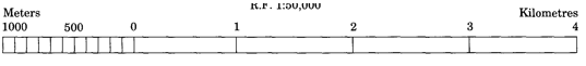
5. Construct a graphical scale when the given R. F. is 1: 50,000 and read the distances in kilometre and metre.
Ans. According to a standard, generally a length of 15 cm is taken to draw a graphical scale. 1:50,000 means that 1 cm on map shows 50,000 cm on ground. In other words, 1 cm shows 50,000 cm.
15 cm shows 50,000 x 15/1,00,000 15 cm= 7.5 km
Since 7.5 km is not an integer, so we can round it off to 5 or 10. Let us round it off to 5 km in this question.
Therefore, we need to make following calculations to express the scale on a length of 5km.
7 .5 km is shown by 15 cm line.
Therefore, for 5 km we can express it as 15 x 5/7.5 0.5 km will be shown by 1 cm on line.
We can make the graph by following steps:
First of all draw a 10 cm line and divide it in 5 important parts. Except one part from the left, let us give all parts a distance of one km. Now divide the first part in 10 equal parts and each part will be equal to 100 metres. We can divide it in five parts as well and taking one part as 200 metre and so on.