Landforms and Their Evolution - Solutions
CBSE Class 11 Geography
NCERT Solutions
Chapter 7
Landforms and Their Evolution
- Multiple choice questions.
- In which of the following stages of landform development, downward cutting is dominated?
- Youth stage
- Late mature stage
- Early mature stage
- Old stage.
- A deep valley characterised by steep step-like side slopes is known as
- U-shaped valley
- Gorge
- Blind valley
- Canyon.
- In which one of the following regions the chemical weathering process is more dominant than the mechanical process?
- Humid region
- Limestone region
- Arid region
- Glacier region.
- Which one of the following sentences best defines the term 'Lapies'?
- A small to medium sized shallow depression
- A landform whose opening is more or less circular at the top and funnel shaped towards bottom
- A landform formed due to dripping water from surface
- An irregular surface with sharp pinnacles, grooves and ridges.
- A deep, long and wide trough or basin with very steep concave high walls at its head as well as in sides is known as:
- Cirque
- Glacial valley
- Lateral Moraine
- Esker.
- In which of the following stages of landform development, downward cutting is dominated?
- Answer the following questions in about 30 words.
- What do incised meanders in rocks and meanders in plains of alluvium indicate?
Ans. A meander, in general, is a bend in a sinous watercourse or river. A meander forms when moving water in a stream erodes the outer banks and widens its valley, and the inner part of the river has less energy and deposits silt. In streams that flow rapidly over steep gradients, normally erosion is concentrated on the bottom of the stream channel. In the case of steep gradient streams lateral erosion on the sides of the valleys is not much when compared to the streams flowing on low and gentle slopes. Because of active lateral erosion, streams flowing over gentle slopes, develop sinuous or meandering courses. It is common to find meandering courses over flood plains and delta plains where stream gradients are very gentle. But very deep and wide meanders can also be found cut in hard rocks. Meander loops develop over original gentle surfaces in the initial stages of development of streams and the same loops get entrenched into the rocks normally due to erosion or slow, continued uplift of the land over which they start. They widen and deepen over time and can be found as deep gorges and canyons in hard rock areas. They give an indication on the status of original land surfaces over which streams have developed.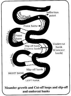
- Explain the evolution of valley sinks or uvalas.
Ans. Quite often the surface run-off simply goes down swallow and sink holes and flow as underground streams and re-emerge at a distance downstream through a cave opening. When sink holes and dolines join together because of slumping of materials along their margins or due to roof collapse of caves, long, narrow to wide trenches called valley sinks or uvalas form. - Underground flow of water is more common than surface run-off in limestone areas. Why?
Ans. The results of the work of groundwater cannot be seen in all types of rocks. But in rocks like limestones or dolomites rich in calcium carbonate, the surface water as well as groundwater through the chemical process of solution and precipitation deposition develop varieties of landforms. These two processes of solution and precipitation are active in limestones or dolomites occurring either exclusively or interbedded with other rocks. Therefore, underground flow of water is more common than surface run off in limestone areas. - Glacial valleys show up many linear depositional forms. Give their locations and names.
Ans. Glacial valleys show up many linear depositional forms. Their locations and names are as follows:- Moraines: A moraine is any glacially formed accumulation of unconsolidated glacial debris (regolith and rock) that occurs in both currently and formerly glaciated regions on Earth (i.e. a past glacial maximum), through geomorphological processes.They are long ridges of deposits of glacial till. Lateral moraines form along the sides parallel to the glacial valleys. The lateral moraines may join a terminal moraine forming a horse-shoe shaped ridge. There can be many lateral moraines on either side in a glacial valley.
- Eskers: Most eskers are argued to have formed within ice-walled tunnels by streams which flowed within and under glaciers. They tended to form around the time of the glacial maximum when the glacier was slow and sluggish. After the retaining ice walls melted away, stream deposits remained as long winding ridges.When glaciers melt in summer, the water flows on the surface of the ice or seeps down along the margins or even moves through holes in the ice. These waters accumulate beneath the glacier and flow like streams in a channel beneath the ice. Such streams flow over the ground with ice forming its banks. Very coarse materials like boulders and blocks along with some minor fractions of rock debris carried into this stream settle in the valley of ice beneath the glacier and after the ice melts can be found as a sinuous ridge called esker.
- Outwash Plains: The large quantities of water that flowed from the melting ice deposited various kinds of materials, the most important of which is called glacial outwash. Outwash plains made up of outwash deposits are characteristically flat and consist of layers of sand and other fine sediments.The plains at the foot of the glacial mountains or beyond the limits of continental ice sheets are covered with glacio-fluvial deposits in the form of broad flat alluvial fans which may join to form outwash plains of gravel, silt, sand and clay.
- Drumlins: Drumlin, oval or elongated hill believed to have been formed by the streamlined movement of glacial ice sheets across rock debris, or till. The name is derived from the Gaelic word druim (“rounded hill,” or “mound”) and first appeared in 1833. Drumlins are smooth oval shaped ridge-like features composed mainly of glacial till with some masses of gravel and sand. The long axes of drumlins are parallel to the direction of ice movement. They may measure up to 1 km in length and 30 m or so in height.
- How does wind perform its task in desert areas? Is it the only agent responsible for the erosional features in the deserts?
Ans. The desert floors get heated up too much and too quickly because of being dry and barren. The heated floors heat up the air directly above them and result in upward movements in the hot lighter air with turbulence, and any obstructions in its path sets up eddies, whirlwinds, updrafts and downdrafts. Winds also move along the desert floors with great speed and the obstructions in their path create turbulence. There are storm winds as well which are very destructive. Winds cause deflation, abrasion and impact. Deflation includes lifting and removal of dust and smaller particles from the surface of rocks. In the transportation process sand and silt act as effective tools to abrade the land surface. The impact is simply sheer force of momentum which occurs when sand is blown into or against a rock surface. It is similar to sand- blasting operation. The wind action creates a number of interesting erosional and depositional features in the deserts. No, wind is not the only agent responsible for the erosional features in the deserts. Wind is one of the two dominant agents in hot deserts. The other one is rain or sheet wash.
- What do incised meanders in rocks and meanders in plains of alluvium indicate?
- Answer the following questions in about 150 words.
- Running water is by far the most dominating geomorphic agent in shaping the earth's surface in humid as well as in arid climates. Explain.
Ans. In humid regions, which receive heavy rainfall running water is considered the most important of the geomorphic agents in bringing about the degradation of the land surface. There are two components of running water. One is overland flow on general land surface as a sheet. Another is linear flow as streams and rivers in valleys. Most of the erosional landforms made by running water are associated with vigorous and youthful rivers flowing over steep gradients. With time, stream channels over steep gradients turn gentler due to continued erosion, and as a consequence, lose their velocity, facilitating active deposition. There may be depositional forms associated with streams flowing over steep slopes. But these phenomena will be on a small scale compared to those associated with rivers flowing over medium to gentle slopes. The gentler the river channels in gradient or slope, the greater is the deposition. When the stream beds turn gentler due to continued erosion, downward cutting becomes less dominant and lateral erosion of banks increases and as a consequence the hills and valleys are reduced to plains.
In dry regions, most of the landforms are formed by the erosion and deposition of flood sheet. Although, in deserts, rain is scarce, it comes down torrentially in a short period of time. The desert rocks devoid of vegetation, exposed to mechanical and chemical weathering processes due to drastic diurnal temperature changes, decay faster and the torrential rains help in removing the weathered materials easily. That means, the weathered debris in deserts is moved by not only wind but also by rain/sheet wash. Running water is the main denudational agent, eroding and transporting sediments and actively shaping the landforms. It acts through process of attrition, vertical and lateral erosion and deposition to shape earth’s surface.
In humid areas running water creates a variety of landforms (aided by others) such as valleys, gorges, etc. in the highlands. Hill slopes devoid of trees are eroded to form rills and gullies. It creates extensive depositional plains in its lower course where the process of deposition becomes dominant, the Indus-Ganga-Brahmaputra plains is a prime example.
In the arid areas (deserts primarily) the scant but suddenly occurring rainfall shapes the landforms creating deep ravines and dry steep valleys called vadiya. The water transports copious amount of sediments, in a landscape deprived of any vegetation to check erosion, creating depositional bahadas and extensive pene plains. - Limestones behave differently in humid and arid climates. Why? What is the dominant and almost exclusive geomorphic process in limestone areas and what are its results?
Ans. Many depositional forms develop within the limestone caves. The chief chemical in limestone is calcium carbonate which is easily soluble in carbonated water i.e. carbon dioxide absorbed rainwater. This calcium carbonate is deposited when the water carrying it in solution evaporates or loses its carbon dioxide as it trickles over rough rock surfaces. Stalactites, Stalagmites and Pillars Stalactites hang as icicles of different diameters. Normally they are broad at their bases and taper towards the free ends showing up in a variety of forms. Stalagmites rise up from the floor of the caves. In facts, stalagmites form due to dripping water from the surface or through the thin pipe, of the stalactite, immediately below it. The results of the work of groundwater cannot be seen in all types of rocks. But in rocks like limestones or dolomites rich in calcium carbonate, the surface water as well as groundwater through the chemical process of solution and precipitation deposition develop varieties of landforms. These two processes of solution and precipitation are active in limestones or dolomites occurring either exclusively or interbedded with other rocks. Therefore, underground flow of water is more common than surface run off in limestones areas. - How do glaciers accomplish the work of reducing high mountains into low hills and plains?
Ans. Masses of ice moving as sheets over the land or as linear flows down the slopes of mountains in broad trough-like valleys are called glaciers. A glacier in its valley is slow unlike water flow. The movement could be a few centimetres to a few metres a day or even less or more. Glaciers move basically because of the force of gravity.
Erosion by glaciers is tremendous because of friction caused by sheer weight of the ice. The material plucked from the land by glaciers get dragged along the floors or sides of the valleys and cause great damage through abrasion and plucking. Glaciers can cause significant damage to even unweathered rocks and can reduce high mountains into low hills and plains.
As glaciers continue to move, debris gets removed, divides get lowered and eventually the slope is reduced to such an extent that glaciers will stop moving leaving only a mass of low hills and vast outwash plains along with other depositional features.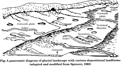
- Running water is by far the most dominating geomorphic agent in shaping the earth's surface in humid as well as in arid climates. Explain.
