Landforms and Their Evolution - Revision Notes
Class 11 Geography
Chapter-7 Landforms and their Evolution
- After weathering, geomorphic agents operate the landforms to change.
- Land form: small to medium reacts or parcels of the earth’s surface are called landforms.
- Several landforms together are called landscape Each landform has its own shape, size and materials Geomorphological processes are slow but significant in long run
- Every landform has a beginning, they change their shape and composition in course of time.
- Due to changes in climate and vertical and horizontal movements landforms change their shape. Each landform undergo three stages called youth, mature and old stages Geomorphology is the science of landforms Various geomorphic agents bring the changes to the landforms such as running water, moving ice, wind glaciers, underground water, waves by erosion and deposition.
- Each geomorphological agent produces its own assemblage of landforms.
- Most of the geomorphological processes are imperceptible.
- The study of the landforms reveals that the stage structure and process of land forms They produce erosional and depositional features.
Factors influencing erosion:
- Rock structures such as fold, fault, joints, fractures, hardness, softness permeability, and impermeability
- Stability of sea level
- Tectonic stability of landmass
- Climate
RUNNING WATER
- In humid regions rainfall is heavy so running water is dominant agent
- there are two components of running water
A. OVERLAND FLOW -SHEET EROSION B. LINEAR FLOW -STREAM EROSION :
Most of the erosional features are formed in upper course/youth full stage of the river Depositional features are formed in the lower course /old stage of the river Steep the slope more the erosion/gentle the slope more the deposition Vertical erosion is more in the upper course lateral erosion is more in the lower course
OVERLAND FLOW: it is also called as sheet erosion. Depending on the irregularities of the surface the sheet erosion concentrate in to channels. Due to sheer friction of the water narrow channels are formed. They are called rills. Rills develop into gullies, gullies further deepen and converted into valleys. In the early stages downward cutting makes waterfalls, cascades in the middle stages streams cut their beds slower and lateral erosion of valley sides becomes severe.
Later stages, the flat valley is formed with monodknocks. This type of plain is called peneplain.
Stages of the river
YOUTH
- Streams are few during this stage with poor integration and
- Flow over original slopes showing shallow V-shaped valleys with no floodplains or with very narrow floodplains along trunk streams.
- Streams divides are broad and flat with marshes, swamp and lakes.
- Meanders if present develop over these broad upland surfaces.
- These meanders may eventually entrench themselves into the uplands.
- Waterfalls and rapids may exist where local hard rock bodies are exposed.
MATURE
- During this stage streams are plenty with good integration.
- The valleys are still V-shaped but deep; trunk streams are broad enough to have wider floodplains within which streams may flow in meanders confined within the valley.
- The flat and broad inter stream areas and swamps and marshes of youth disappear and the stream divides turn sharp.
- Waterfalls and rapids disappear.
OLD
- Smaller tributaries during old age are few with gentle gradients.
- Streams meander freely over vast floodplains showing natural levees, oxbow lakes, etc.
- Divides are broad and flat with lakes, swamps and marshes.
- Most of the landscape is at or slightly above sea level.
EROSIONAL LANDFORMS ‘V SHAPED VALLEY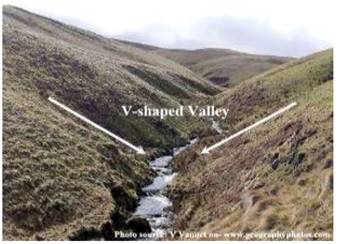
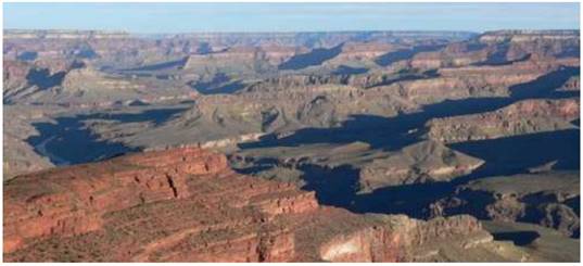
GORGE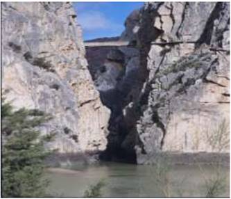
CANYON
DIFFERENCE BETWEEN GORGE AND CANYON :
| GORGE | CANYON |
| 1. steep sides | 1. Step like sides |
| 2. equal width of top and bottom | 2.wider at the top and narrow at the bottom |
| 3. small in length | 3. Longer in length |
| 4. they are found in semi arid lands grand canyon bramhaputra gorge | 4. Found in dry areas ex. Grand |
POT HOLES: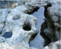
- They are circular depressions
- formed by abrasion
- pebbles and boulders get collected in these holes and rotated and make depression wider and deep
- They keep valley deepened 5.at the foot of the water falls they become plunge pools
PLUNGE POOLS: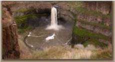
- Found Foot Of The Water Falls
- Formed Due To Soft Rocks
- They Are Below The Level Of River Bed
MEANDERS: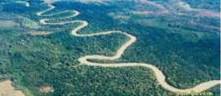
Into oxbow lakes
- Lateral erosion is common in the lower course of the rivers
- Due to low kinetic energy water is changing its course
- Generally found in the flood plains
- When meanders are found in deep and hard rocky areas they are called incised or entrenched meanders
- Same meanders develop loops which later on converted into oxbow lakes
- Some times they deepen the rocks and converted into canyons
RIVER TERRACES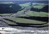
- River terraces are surfaces marking old valley floor or floodplain levels.
- They may be bedrock surfaces without any alluvial cover or alluvial terraces consisting of stream deposits.
- River terraces are basically products of erosion as they result due to vertical erosion by the stream into its own depositional floodplain.
- There can be a number of such terraces at different heights indicating former river bed levels.
- The river terraces may occur at the same elevation on either side of the rivers in which case they are called paired terraces
- Unpaired terraces are found in the areas of slow upliftment areas Reasons for the formation of river terraces.
- receding water after a peak flow
- change in hydrological regime due to climatic change
- tectonic uplift of land
- sea level changes incase of rivers closer to the sea alluvial fans.
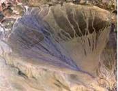
- Found near the foot of the hills
- The river break into number of channels
- Low gradient
- Coarse load is deposited
- Low gradient
- Cone shaped deposit
- Channels shift their position in the plain
- They are called distributaries
- Cones are gentle slope in humid areas and dry lands they have steep __ slope
ALLUVIALPLAIN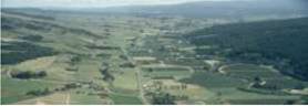
Formed along the river banks
- Made of alluvial soils
- They are divided into two types khadar and bangar
- Khadar soils are found near the river and bangar soils are found away from the river
- They are very fertile
DELTAS
- Deltas are like alluvial fans but develop at a different location.
- The load carried by the rivers is dumped and spread into the sea.
- If this load is not carried away far into the sea or distributed along the coast, it spreads and accumulates as a low cone.
- Unlike in alluvial fans, the deposits making up deltas are very well sorted with clear stratification. The coarsest materials settle out first and the finer fractions like silts and clays are carried out into the sea.
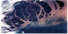
- They are in triangular shape 5. Similar to Greek letter Delta 6. Divided by distributaries 7. Deposited material is stratified on the basis of size. Coarse material is deposited first and then fine material
GANGA DELTA FLOOD PLAINS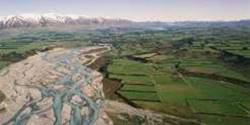
- Major landorms in the river deposition 2.big boulders are deposited first and then fine material is carried to the longer distance. The active flood plain is found in the river bank where as inactive flood plain is found above the level of river bank. The flood plains in deltas are called delta plains.
NATURAL LEEVES: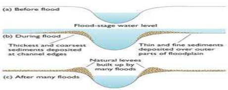
They are associated with flood plains. found along the flood plains of large rivers. they are low linear, parallel ridges made of coarse material found along the river bank. When river shift laterly a series of natural levees can form
POINT BARS: they are also called as meander bars. 2.found along the convex side of meanders of large rivers. They are uniform in profile. if there are more then one ridge narrow and elongated depressions are found in between the point bars.
MEANDERS: Meander is not a landform but is only a type of channel pattern. This is because of:
- propensity of water flowing over very gentle gradients to work laterally on the banks;
- unconsolidated nature of alluvial deposits making up the banks with many irregularities which can be used by water exerting pressure laterally;
- coriolis force acting on the fluid water deflecting it like it deflects the wind.
When the gradient of the channel becomes extremely low, water flows leisurely and starts working laterally.
Formation of OXBOW LAKES: Found along the river bank on the convex side of the meander.
Convex side is deposited and concave side is eroded. Concane bank is eroded and also it is called cutoff bank convex side is long gentle slope. as they grow long loops the curve is cutoff and formed into Oxbow lakes.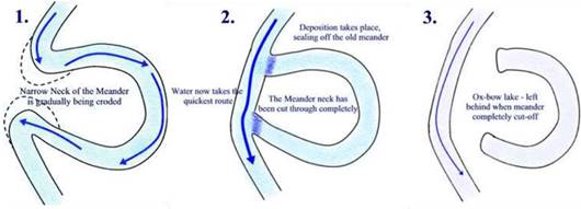
BRAIDED CHANNEL
When rivers carry coarse material, there can be selective deposition of coarser materials causing formation of a central bar, which diverts the flow towards the banks; and this flow increases lateral erosion on the banks. As the valley widens, the water column is reduced and more and more materials are deposited as islands and lateral bars developing a number of separate channels of water flow.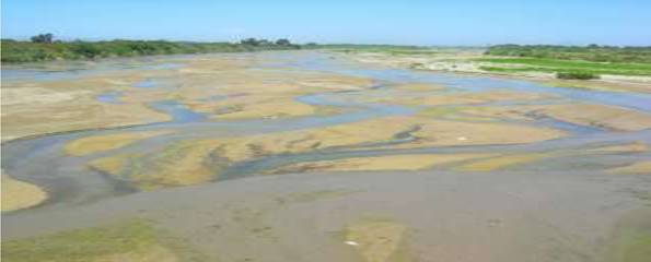
KARST TOPOGRAPHY. Any limestone or dolomitic region showing typical landforms produced by the action of groundwater through the processes of solution and deposition is called Karsttopography after the typical topography developed in limestone rocks of Karst region in the Balkans adjacent to Adriatic Sea.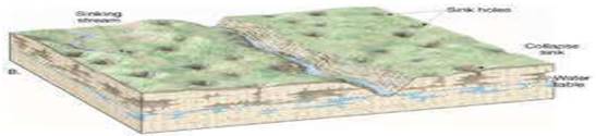
Pools, Sinkholes, Lapis and Limestone Pavements
Small to medium sized round to sub-rounded shallow depressions called swallow holes form on the surface of lime stones through solution.
Sinkholes are very common in limestone/karst areas. A sinkhole is an opening more or less circular at the top and funnel-shaped towards the bottom with sizes varying in area from a few sq. m to a hectare and with depth from a less than half a metre to thirty metres or more. The term doline is sometimes used to refer the collapse sinks. Solution sinks are more common than collapse sinks. Quite often the surface run-off simply goes down swallow and sink holes and flow as underground streams and re-emerge at a distance downstream through a cave opening. When sinkholes and dolines join because of slumping of materials along their margins or due to roof collapse of caves, long, narrow to wide trenches called valleysinks or Uvalas form. Gradually, most of the surface of the limestone is eaten away by these pits and Trenches, leaving it extremely irregular with a maze of points, grooves and ridges or lapies. Especially, these ridges or lapies form due to differential solution activity along parallel to subparallel joints. The lapie field may eventually turn into somewhat smooth limestone pavements.
Caves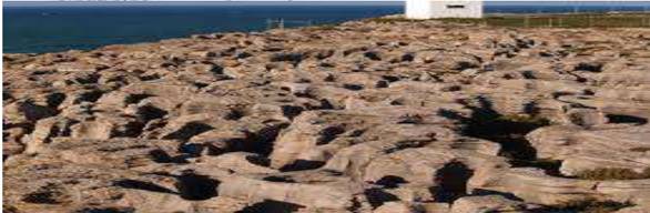
In areas where there are alternating beds of rocks with limestone or dolomites in between or in areas where, limestone are dense, massive and occurring as thick beds, cave formation is prominent. Water percolates down either through the materials or through cracks and joints and moves horizontally along bedding planes. It is along these bedding planes that the limestone dissolves and long and narrow to wide gaps called caves
Depositional Landforms
Many depositional forms develop within the limestone caves. The chief chemical in lime stone is calcium carbonate, which is easily soluble in carbonated water (carbon dioxide absorbed rainwater). This calcium carbonate is deposited when the water carrying it in solution evaporates or loses its carbon dioxide as it trickles over rough rock surfaces. Stalactites, Stalagmites and Pillars Stalactites hang as icicles of different diameters. Normally they are broad at their bases and taper towards the free ends showing up in a variety of forms. Stalagmites rise up from the floor of the caves. In fact, stalagmites form due to dripping water from the surface or through the thin pipe, of the stalactite, immediately below it,. Stalagmites may take the shape of a column, a disc, with either a smooth, rounded bulging end or a miniature crater like depression. The stalagmite and stalactites eventually fuse to give rise to columns and pillars of different diameters Difference between stalagmites and stalactites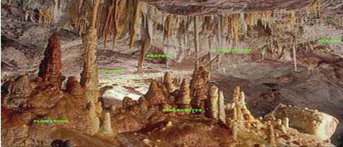
| STALAGMITES | STALACTITES |
|
|
GLACIERS
Masses of ice moving as sheets over the land (continental glacier or piedmont glacier if a vast sheet of ice is spread over the plains at the foot of mountains) or as linear flows down the slopes of mountains in broad trough-like valleys (mountain and valley glaciers) are called glaciers.
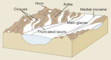
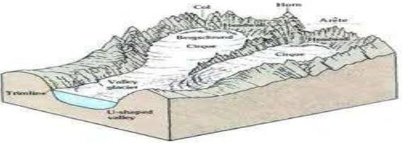
Cirque
- Cirques are the most common of landforms in glaciated mountains.
- The cirques quite often are found at the heads of glacial valleys.
- The accumulated ice cuts these cirques while moving down the mountain tops.
- They are deep, long and wide troughs or basins with very steep concave to vertically dropping high walls at its head as well as sides.
- Horns and Serrated Ridges Horns form through head ward erosion of the cirque walls. If three or more radiating glaciers cut head ward until their cirques meet, high, sharp pointed and steep sided peaks called horns form.
- The divides between cirque sidewalls or head walls get narrow because of progressive erosion and turn into serrated or saw-toothed ridges sometimes referred to as aretes with very sharp crest and a zig-zag Outline.
MORAINS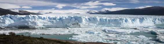
Glacial Valleys/Troughs
- Glaciated valleys are trough-like and U-shaped with broad floors and relatively smooth, and steep sides.
- The valleys may contain littered debris or debris shaped as moraines with swampy appearance. There may be lakes gouged out of rocky floor or formed by debris within the valleys.
- There can be hanging valleys at an elevation on one or both sides of the main glacial valley.
- The faces of divides or spurs of such hanging valleys opening into main glacial valleys are quite often truncated to give them an appearance like triangular facets.
- Very deep glacial troughs filled with sea water and making off shore lines are called fjords/fiords. fiords at the Norway coast Depositional Landforms
The un assorted coarse and fine debris dropped by the melting glaciers is called glacial till. Most of the rock fragments in till are angular to sub angular in form. Streams form by melting ice at the bottom, sides or lower ends of glaciers.
Some amount of rock debris small enough to be carried by such melt-water streams is washed down and deposited. Such glacio-fluvial deposits are called outwash deposits.
Unlike till deposits, the outwash deposits are roughly stratified and assorted. The rock fragments in outwash deposits are somewhat rounded at their edges. Figure 7.14 shows a few depositional landforms commonly found In glaciated areas.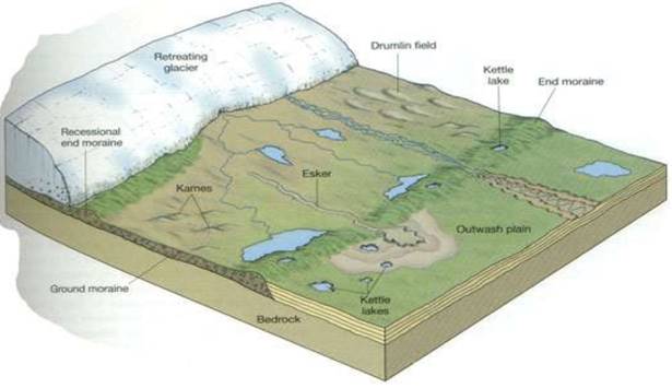
TYPES OF MORAINS
They are long ridges of deposits of glacial till. Terminal moraines are long ridges of debris deposited at the end of the glaciers. Lateral moraines form along the sides parallel to the glacial valleys. The lateral moraines may join a terminal moraine forming a horse-shoe shaped ridge .There can be many lateral moraines on either side in a glacial valley. These moraines partly or fully owe their origin to glacio fluvial waters pushing up materials to the sides of glaciers. Many valley glaciers retreating rapidly leave an irregular sheet of till over their valley floors. Such deposits varying greatly in thickness and in surface topography are called ground moraines. The moraine in the center of the glacial valley flanked by lateral moraines is called medial moraine. They are imperfectly formed as compared to lateral moraines. Sometimes medial moraines are indistinguishable from ground moraines.
Eskers
- When glaciers melt in summer, the water flows on the surface of the ice or seeps down along the margins or even moves through holes in the ice.
- These waters accumulate beneath the glacier and flow like streams in a channel beneath the ice.
- Such streams flow over the ground (not in a valley cut in the ground) with ice forming its banks.
- Very coarse materials like boulders and blocks along with some minor fractions of rock debris carried into this stream settle in the valley of ice beneath the glacier and after the ice melts can be found as a sinuous ridge called esker.
Outwash Plains
The plains at the foot of the glacial mountains or beyond the limits of continental ice sheets are covered with glacio-fluvial deposits in the form of broad flat alluvial fans which may join to form outwash plains of gravel, silt, sand and clay. Distinguish between river alluvial plains and glacial outwash plains.
Drumlins
Drumlins are smooth oval shaped ridge-like features composed mainly of glacial till with some masses of gravel and sand. The long axes of drumlins are parallel to the direction of ice movement. They may measure up to 1 km in length and 30 m or so in height. One end of the drumlins facing the glacier called the stossend is blunter and steeper than the other end called tail. The drumlins form due to dumping of rock debris beneath heavily loaded ice through fissures in the glacier. The stoss end gets blunted due to pushing by moving ice. Drumlins give an indication of direction of glacier movement.
COASTAL LAND FORMS
Other than the action of waves, the coastal landforms depend upon :
- the configuration of land and sea floor;
- whether the coast is advancing (emerging) seaward or retreating (submerging) landward. Assuming sea level to be constant,
two types of coasts are considered to explain the concept of evolution of coastal landforms:
- high, rocky coasts (submerged coasts);
- low, smooth and gently sloping sedimentary coasts (emerged coasts
HIGH ROCKY COASTS
- Along the high rocky coasts, the rivers appear to have been drowned with highly irregular coastline. The coastline appears highly indented with extension of water into the land where glacial valleys (fjords) are present.
- Along high rocky coasts, waves break with great force against the land shaping the hill sides into cliffs. With constant pounding by waves, the cliffs recede leaving a wave-cut platform in front of the sea cliff..
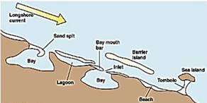
- Bars are submerged features and when bars show up above water, they are called barrier bars. Barrier bar which get keyed up to the headland of a bay is called a spit.
- When barrier bars and spits form at the mouth of a bay and block it, a lagoon forms.
- The lagoons would gradually get filled up by sediments from the land giving rise to a coastal plain.
LOW SEDIMENTARY COASTS
- Along low sedimentary coasts the rivers appear to extend their length by building coastal plains and deltas. The coastline appears smooth with occasional incursions of water in the form of lagoons and tidal creeks.
- The land slopes gently into the water. Marshes and swamps may abound along the coasts. Depositional features dominate. When waves break over a gently sloping sedimentary coast, the bottom sediments get churned and move readily building bars, barrier bars, spits and lagoons. Lagoons would eventually turn into a swamp which would subsequently turn into a coastal plain.
- The west coast of our country is a high rocky retreating coast. Erosional forms dominate in the west coast. The east coast of India is a low sedimentary coast. Depositional forms dominate in the east coast.
EROSIONAL LANDFORMS Cliffs, Terraces, Caves and Stacks
Wave-cut cliffs and terraces are two forms usually found where erosion is the dominant shore process. Almost all sea cliffs are steep and may range from a few m to 30 m or even more. At the foot of such cliffs there may be a flat or gently sloping platform covered by rock debris derived from the sea cliff behind. Such platforms occurring at elevations above the average height of waves is called a wave-cut terrace.
EROSIONAL FEATURES OF WAVES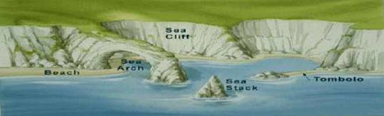
The lashing of waves against the base of the cliff and the rock debris that gets smashed against the cliff along with lashing waves create hollows and these hollows get widened and deepened to form sea caves.
The roofs of caves collapse and the sea cliffs recede further inland. Retreat of the cliff may leave some remnants of rock standing isolated as small islands just off the shore. Such resistant masses of rock, originally parts of a cliff or hill are called sea stacks.
Like all other features, sea stacks are also temporary and eventually coastal hills and cliffs will disappear because of wave erosion giving rise to narrow coastal plains, and with onrush of deposits from over the land behind may get covered up by alluvium or may get covered up by shingle or sand to form a wide beach.
DEPOSITIONAL LANDFORMS Beaches and Dunes
Beaches are characteristic of shorelines that are dominated by deposition, but may occur as patches along even the rugged shores. Most of the sediment making up the beaches comes from land carried by the streams and rivers or from wave erosion. Beaches are temporary features. The sandy beach which appears so permanent may be reduced to a very narrow strip of coarse pebbles in some other season. Most of the beaches are made up of sand sized materials. Beaches called shingle beaches contain excessively small pebbles and even cobbles.
Bars, Barriers and Spits
A ridge of sand and shingle formed in the sea in the off-shore zone (from the position of low tide waterline to seaward) lying approximately parallel to the coast is called an off-shore bar.
An off-shore bar which is exposed due to further addition of sand is termed a barrier bar.
The off-shore bars and barriers commonly form across the mouth of a river or at the entrance of a bay. Sometimes such barrier bars get keyed up to one end of the bay when they are called spits (Figure 7.15). Spits may also develop attached to headlands/hills.
The barriers, bars and spits at the mouth of the bay gradually extend leaving only a small opening of the bay into the sea and the bay will eventually develop into a lagoon.
The lagoons get filled up gradually by sediment coming from the land or from the beach itself (aided by wind) and a broad and wide coastal plain may develop replacing a lagoon.
Depositional features of the sea waves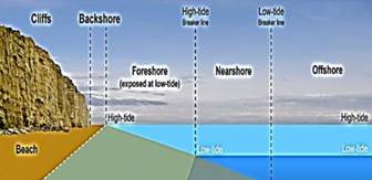
WINDS
Wind is one of the two dominant agents in hot deserts.
Winds cause deflation, abrasion and impact.
Deflation includes lifting and removal of dust and smaller particles from the surface of rocks.
In the transportation, process sand and silt act as effective tools to abrade the land surface.
The impact is simply sheer force of momentum, which occurs when sand is blown into or against a rock surface
EROSIONAL LANDFORMS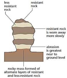
Pediments and Pedi plains
Landscape evolution in deserts is primarily concerned with the formation and extension of pediments. Gently inclined rocky floors close to the mountains at their foot with or without a thin cover of debris, are called pediments.
Erosion starts along the steep margins of the landmass or the steep sides of the tectonically controlled steep incision features over the landmass. Once, pediments are formed with a steep wash slope followed by cliff or free face above it, the steep wash slope and free face retreat backwards. This method of erosion is termed as parallel retreat of slopes through back wasting.
That’s how the high relief in desert areas is reduced to low featureless plains called Pedi plains. Playas Plains are by far the most prominent landforms in the deserts. In basins with mountains and hills around and along, the drainage is towards the center of the basin and due to gradual eposition of sediment from basin margins, a nearly level plain forms at the center of the basin. In times of sufficient water, this plain is covered up by a shallow water body.The playa plain covered up by salts is called alkaliflats.
Deflation Hollows and Caves
Weathered mantle from over the rocks or bare soil, gets blown out by persistent movement of wind currents in one direction. This process may create shallow depressions called deflation hollows.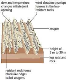
Deflation also creates numerous small pits or cavities over rock surfaces. The rock faces suffer impact and abrasion of wind-borne sand and first shallow depressions called blow outs are created, and some of the blow outs become deeper and wider fit to be called caves.
Mushroom, Table and Pedestal Rocks Many rock-outcrops in the deserts easily susceptible to wind deflation and abrasion are worn out quickly leaving some remnants of resistant rocks polished beautifully in the shape of mushroom with a slender stalk and a broad and rounded pear shaped cap above. Wind is a good sorting agent. Depending upon the velocity of wind, different sizes of grains are moved along the floors by rolling or saltation and carried in suspension and in this process of transportation itself, the materials get sorted. When the wind slows or begins to die down, depending upon sizes of grains and their critical velocities, the grains will begin to settle.
Sand Dunes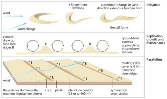
Dry hot deserts are good places for sand dune formation. Obstacles to initiate dune formation are equally important. There can be a great variety of dune forms Crescent shaped dunes called barchans with the points or wings directed away from wind direction i.e., downwind, form where the wind direction is constant and moderate and where the original surface over which sand is moving is almost uniform.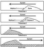
Seif is similar to barchan with a small difference. Seif has only one wing or point.The lone wings of seifs can grow very long and high.They appear as long ridges of considerable length but low in height.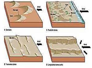
Transverse dunes are aligned perpendicular to wind direction. These dunes form when the wind direction is constant and the source of sand is an elongated feature at right angles to the wind direction. They may be very long and low in height. When sand is plenty, quite often, the regular shaped dunes coalesce and lose their individual characteristics.
