Introduction to Remote Sensing - Solutions
CBSE Class 11 Geography
NCERT Solutions
Chapter 30
Introduction of Remote Sensing
1. Choose the right answer from the four alternatives given below
(i) Remote sensing of objects can be done through various means such as A. remote sensors, B. human eyes and C. photographic system. Which of the following represents the true order of their evolution?
(a) ABC
(b) BCA
(c) CAB
(d) None of the above
Ans. (b) BCA
(ii) Which of the following regions of Electromagnetic spectrum is not used in satellite remote sensing?
(a) Microwave region
(b) Infrared region
(c) X-rays
(d) visible region
Ans. (c) X-rays
(iii) Which of the following is not used in visual interpretation technique?
(a) Spatial arrangements of objects
(b) Frequency of tonal change on the image
(c) Location of objects with respect to other objects
(d) Digital image processing
Ans. (a) Spatial arrangements of objects
2. Answer the following questions in about 30 words.
(i) Why is remote sensing a better technique than other traditional methods?
Ans. Remote sensing is a better technique than traditional methods because:
(a) It presents the concise picture of a large area.
(b) It provides real or nearly real pictures on time base line.
(c) It is less expensive as compared to land survey and we can easily collect information by using it.
(d) It converts energy received into photographic/digital form of data.
(e) It is not affected by bad weather and inaccessible land. (f) It does not make physical contact with the object. (g) It generally refers to the use of satellite or aircraft-based sensor technologies to detect and classify objects on the Earth, unlike traditional methods.
(ii) Differentiate between IRS and INSAT series of satellites.
IRS | INSAT Series of Satellites |
It stands for Indian Remote Sensing. | It stands for Indian National Satellite System. |
The sensors recording the energy that they receive are placed in a near- polar sun synchronous orbit at an altitude of 700 - 900 km. These satellites are known as remote sensing satellites. | As against these satellites, the weather monitoring and telecommunication satellites are placed in a Geostationary position (the satellite is always positioned over its orbit that synchronises with the direction of the rotation of the earth) and revolves around the earth (coinciding with the direction of the movement of the earth over its axis) at an altitude of nearly 36,000 km (e.g. INSAT series of satellites). |
Indian Remote Sensing (IRS) satellite system was commissioned with the launch of IRS-1A, in 1988. With ten satellites in operation, IRS is the largest civilian remote sensing satellite constellation in the world. Indian Remote Sensing (IRS) satellite system was commissioned with the launch of IRS-1A, in 1988. | The Indian National Satellite (INSAT) system which are placed in Geo-stationary orbits is one of the largest domestic communication satellite systems in Asia-Pacific region. Established in 1983 with commissioning of INSAT-1B, it initiated a major revolution in India's communications sector and sustained the same later. INSAT space segment consists of 24 satellites out of which 10 are in service (INSAT-2E, INSAT-3A, INSAT-4B, INSAT-3C, INSAT-3E, KALPANA-1, INSAT-4A, INSAT-4CR, GSAT-8 and GSAT-12). |
| IRS has 12 operational satellites. | INSAT has 24 satellites. |
| These satellites are used to collect data which can be used for agriculture, water resources and urban development among other fields. | They are used in communication, T. V. broadcasting and meteorological services. |
| IRS is the world's largest Civilian Remote Sensing System. | INSAT is one of the largest domestic communication system satellite systems in Asia- Pacific region. |
| The IRS satellites are placed in the polar orbits. | INSAT is a network of satellites in the geostationary orbit. |
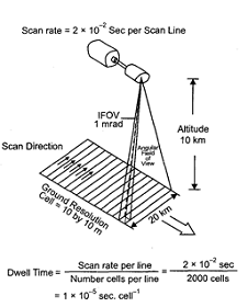
(iii) Describe in brief the functioning of push¬broom scanner.
Ans. The pushbroom scanner is a device for obtaining images with spectroscopic sensors. They are regularly used for passive remote sensing from space. The pushbroom scanners consist of a number of detectors which are equivalent to the number obtained by dividing the swath of the sensor by the size of the spatial resolution. In pushbroom scanner, all detectors are linearly arrayed and each detector collects the energy reflected by the ground cell (pixel) dimensions of 20 metres at a nadir's view.
For example, the swath of High Resolution Visible Radiometer - 1 (HRVR-1) of the French remote sensing satellite SPOT is 60 km and the spatial resolution is 20 metres. If we divide 60 km x 1000 metres/20 metres, we get a number of 3000 detectors that are deployed in SPOT HRV -1 sensor.
3. Answer the following questions in about 125 words.
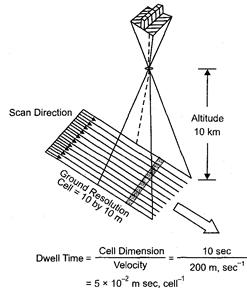
(i) Describe the operation of a whiskbroom scanner with the help of a diagram. Explain how it is different from push-broom scanner.
Ans. Whiskbroom Scanners: A whiskbroom or spotlight sensor, is a technology for obtaining satellite images with optical cameras. It is used for passive remote sensing from space. The whiskbroom scanners are made up of a rotating mirror and a single detector. The mirror is so oriented that when it completes a rotation, the detector sweeps across the field of view between 90° and 120° to obtain images in a large number of narrow spectral bands ranging from visible to middle infrared regions of the spectrum. The total extent of the oscillating sensor is known as the Total Field of View (TFOV) of the scanner. While scanning the entire field, the sensor's optical head is always placed at a particular dimension called the Instantaneous Field of View (IFOV). Figure given below depicts the scanning mechanism of whiskbroom scanners.
(a) In whiskbroom seanner, a single mirror is used to reflect light onto a single detector. The mirror moves back and forth to collect measurements from one pixel in the image at a time whereas in pushbroom scanner a line of detectors arranged in perpendicular to flight direction are used. The image is collected one line at a time with all of the pixels in a line measures simultaneously.
(b) A pushbroom scanner receives stronger signals than whiskbroom scanner because it looks at each pixel area for long.
(c) Pushbroom scanner is more sensitive than whiskbroom scanner. So it is needed to perfectly calibrate. (d) A pushbroom scanner collects data along track using a row of sensors arranged perpendicular to the direction of travel whereas a whiskbroom scanner uses a rotating mirror to scan across track to collect data. (e) A pushbroom scanner collects data row by row whereas a whiskbroom scanner records the data one pixel at a time. (f) An example of pushbroom scanner is a Flatbed camera used to scan photographs, and an example of whiskbroom scanner is a bar-code scanner that uses a laser beam to scan the barcode.
(ii) Identify and list the changes that can be observed in the vegetation of Himalaya.
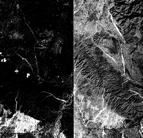
Ans. Mountains are the most remarkable landforms on Earth's surface with prominent vegetation zones based mainly on Attitudinal and climatic variations. The Himalayas are experiencing the most drastic climatic change outside of the poles. The climate change threatens rare, endemic and useful Himalayan plant species. The Himalayan ranges show a succession of vegetation from the tropical to the tundra, with change in with the altitude. Deciduous forests are found in the foothills of the Himalayas. It is succeeded by the wet temperate type of forests between an altitude of 1,000-2,000 m. After 3000 metre altitude, conical forests are found which have sharp leaves. Important trees in this region are Chid, Fur, Pine, Sprus etc. The red patches in May image refer to Coniferous vegetation. In November image the additional red patches refer to Deciduous plants and the light red colour is related to the crops.
