Introduction to Maps - Solutions
CBSE Class 11 Geography
NCERT Solutions
Chapter 24
Introduction to Maps
1. Choose the right answer from the four alternatives given below:
(i) Which one of the following is essential for the network of lines and polygons to be called a map?
(a) Map Legend
(b) Symbols
(c) North Direction
(d) Map Scale.
Ans. (d) Map Scale. It refers to the ratio between distance on a map and the corresponding distance on the ground.
(ii) A map bearing a scale of 1: 4000 and larger is called:
(a) Cadastral map
(b) Topographical map
(c) Wall map
(d) Atlas map.
Ans. (a) Cadastral map. It shows the boundaries and ownership of land parcels.
(iii) Which one of the following is NOT an essential element of maps?
(a) Map Projection
(b) Map Generalisation
(c) Map Design
(d) History of Maps
Ans. (d) History of Maps. It gives us an outline of the sequences in the development of the science of map-making.
2. Answer the following questions in about 30 words:
(i) What is map generalisation?
Ans. Map generalization, is a method for deriving a smaller-scale map from a larger scale map or map data to produce a map at a certain scale with a defined and readable legend. As maps are drawn at a reduced scale to serve a definite purpose, it is the job of a cartographer is to generalise the map contents. In doing so, a cartographer must select the data relevant to the selected theme and simplify it as per the needs. It is called map generalization. Every map is drawn with a definite objective. For example, a general purpose map is drawn to show information of a general nature such as relief, drainage, vegetation, settlements, means of transportation, etc. Similarly, a special purpose map exhibits information pertaining to one or more selected themes like population density, soil types or location of industries. It is, therefore, necessary to carefully plan the map contents while the purpose of the map must be kept in the forefront.
(ii) Why is map design important?
Ans. Map Design is very important to make the maps simple to use and easy to understand. It involves the planning of graphic characteristics of maps including the selection of appropriate symbols, their size and form, style of lettering, specifying the width of lines, selection of colours and shades, arrangement of various elements of map design within a map and design for map legend. The map design is a complex aspect of map- making and requires thorough understanding of the principles that govern the effectiveness of graphic communication.
(iii) What are different types of small-scale maps?
Ans. Small scale refers to World maps of maps of large regions like continents or large nations. In other words, they show large areas of land on a small space. They are called small scale because the representative fraction is relatively small. Small-scale maps are divided into two types:
(a) Wall Maps: These maps are generally drawn on large size paper or on plastic base for use in classrooms or lecture halls. The scale of wall maps is generally smaller than the scale of topographical maps but larger than atlas maps.
(b) Atlas Maps: Atlas maps are very small-scale zraps. These maps represent fairly large areas and present highly generalised picture of the physical or cultural features. Even so, an atlas map serves as a graphic encyclopaedia of the geographical information about the world, continents, countries or regions.
(iv) List out two major types of large-scale maps?
Ans. A large scale map shows a large amount of detail while representing a limited area such as neighborhoods or towns. Large-scale maps are divided into two types:
(a) Cadastral maps: The term 'cadastral' is derived from the French word 'cadastre' meaning 'register of territorial property'. These maps are drawn to show the ownership oflanded property by demarcating field boundaries of agricultural land and the plan of individual houses in urban areas. The cadastral maps are prepared by the government agencies to realise revenue and taxes, along with keeping a record of ownership.
(b) Topographical Maps: These maps are also prepared on a fairly large scale. The topographical maps are based on precise surveys and are prepared in the form of series of maps made by the national mapping agencies of almost all countries of the world. These maps follow uniform colours and symbols to show topographic details such as relief, drainage, agricultural land, forest, settlements, means of communication, location of schools, post offices and other services and facilities.
(v) How is a map different from a sketch?
Ans. A sketch is a simplified map drawn freehand which fails to preserve the true scale or orientation.
Map is a part of the earth's surface on a plane surface at a reduced scale. It may also be understood that a simple network of lines and polygons without a scale shall not be called a map. It is only referred to as "the sketch". In simple words, map has a specific scale and sketch does not have a scale. Map is drawn scientifically and sketch is drawn roughly. Sketch drawing is an art while map making is a science and science of maps is called cartography.
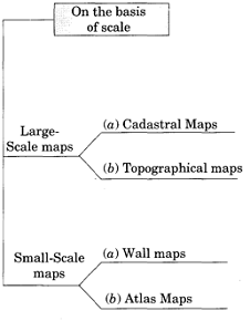
On the basis of scale:
1. Large-scale maps: These maps are drawn to show small areas at a relatively large-scale. For example, the topographical maps drawn at a scale of 1 : 250,000, 1 : 50,000 or
1 : 25,000 and the village maps, the zonal plans of the cities and house plans prepared on a scale of 1 : 4,000, 1 : 2,000 and 1 : 500 are large-scale maps.
These are of two types:
(a) Cadastral Maps
(b) Topographical Maps
2. Small-scale maps: These maps are drawn to show large areas. These are of two types:
(a) Wall Maps and
(b) Atlas Maps
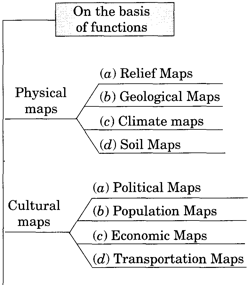
On the basis of functions, maps are of two types:
1. Physical maps: Physical maps show natural features such as relief, geology, soils, drainage, elements of weather, climate and vegetation, etc. Physical maps include relief maps, geological maps and climatic maps.
2. Cultural maps: Cultural maps show man-made features. These include a variety of maps showing population distribution and growth, sex and age, social and religious composition, literacy, levels of educational attainment, occupational structure, location of settlements, facilities and services, transportation lines and production, distribution and flow of different commodities. It includes political maps, population maps, economic maps and transportation maps.
