Interior of The Earth - Revision Notes
Class 11 Geography
Chapter-3 Interior of the Earth
This chapter deals with :
- Sources of information of about the earth's interior
- Direct sources
- Indirect sources
- Earthquake
- Earthquake waves
- Propagation of earthquake waves
- Emergence of shadow zone
- Types of earthquakes
- Effects of earthquakes
- Structure of the earth
- The crust
- The mantle
- The core
- Volcanoes and volcanic landforms
- Types of volcanoes
- Shield volcano
- Composite volcanoes
- Caldera
- Flood basalt provinces
- Mid ocean ridge volcanoes
- Volcanic landforms intrusive forms, plutonic rocks, batholiths, laccoliths, lapolith, phacolith, sills & dykes
Sources of Information about the Earth’s Interior: The knowledge about interior of the earth is obtained through direct sources and indirect sources. Direct sources include rock materials from mining areas and molten magma from volcanic eruptions. Besides, scientists are working on “Deep Ocean drilling Project” and “Integrated Ocean Drilling Project”.
There are two sources for information about interior of the earth - a) Direct Sources and b) Indirect Sources:
Direct Sources: Mining, drilling and volcanic eruption are examples of direct sources. During the process of mining and drilling rocks and minerals are extracted which gives information that there are layer system in the crust. Crust is made of many kinds of rocks and minerals. Volcanic eruption suggests that there is some zone inside the earth which is very hot and in liquid condition. Direct sources are not very reliable because mining and drilling can be done only up to some depth only.
Indirect Sources: Seismic waves, gravitational field, magnetic field, falling meteors etc are example of indirect sources. They are very important for know about earth’s interior. Movement of seismic wave suggests that there are three layers in the earth and each layer has different density. Density increases toward the center of the earth.
Movement of seismic wave suggests two things: a) There are three layers in the earth and b) Each layer has different density which increases toward the center of the earth.
EARTH QUAKE
An Earthquake is a sudden violent shaking of the ground, typically causing great destruction, as a result of movements within the earth's crust or volcanic action.in other words, It is a natural event. It is caused due to release of energy, which generates waves that travel in all directions.
WHY DOES EARTH SHAKE?
The release of energy occurs along a fault. A fault is a sharp break in the crustal rocks. Rocks along a fault tend to move in opposite directions. As the overlying rock strata press them, the friction locks them together. However, their tendency to move apart at some point of time overcomes the friction.
Rocks along the fault tend to move in opposite directions as the overlying strata press them the friction locks them together.They slide over another: as a result energy releases.Energy waves travel in all directions. The point where energy releases is called focus/hypocenter Above the focus point on the surface it is called epicenter
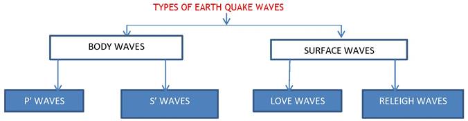
EARTHQUAKE WAVES
All natural earthquakes take place in the lithosphere. Earthquake waves are seismic waves that are created when energy builds up in rocks and they fracture. Scientists estimate there are several million earthquakes each year. Earthquake waves are basically of two types — body waves and surface waves. Every earthquake produces P waves and S waves but only larger earthquakes produce Love waves and Rayleigh waves. These are the four major types of seismic waves. All earth quakes take place in the lithosphere (200 km depth).
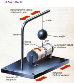
An instrument called Seismograph records the waves.
Earthquake and Seismic Waves :
- Meaning of Earthquake: Sudden movement or vibration on the earth surface is called earthquake. In other words, An earthquake in simple words is shaking of the earth. An earthquake may be produced due to:
- rising of magma,
- folding and faulting,
- movement of plates,
- violent volcanic eruption etc.
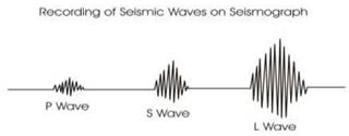
- When earthquake occurs, three types of wave are produced called as seismic waves.
- These are:
- P or Primary Wave,
- S or Secondary Wave, and
- L or Long or Surface Wave.
P and S waves are combinely called as ‘Body Wave' as they move inside the body of the earth.
- P or Primary Wave: P-waves move faster and are the first to arrive at the surface. These are also called ‘primary waves’. The P-waves are similar to sound waves. They travel through gaseous, liquid and solid materials.
- S or Secondary Wave: S-waves arrive at the surface with some time lag. These are called secondary waves. An important fact about S-waves is that they can travel only through solid materials. This characteristic of the S-waves is quite important.
- L or Long or Surface Wave : L wave is the slowest wave. It moves on the earth surface. It causes maximum destruction on the earth surface.
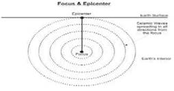
Focus: It is point inside the earth surface from where an earthquake starts.The ground ruptures at this spot, then seismic waves radiate outward in all directions. It is always hidden inside the earth. Focus of an earthquake may be found at the depth of 100-200 km.
Epicenter: An earthquake epicenter is the point on the Earth's surface directly above the earthquake focus.The epicenter is the geographical location of the earthquake reported on television stations and written reports about earthquakes. It is a point on the earth surface which records the seismic waves for the first time. Maximum destruction from an earthquake is caused on the epicenter. Epicenter is located just perpendicular to the focus.
Richter Scale: It is an scale which measures the magnitude of an earthquake. In other words, energy released by an earthquake is measured on Richter Scale. Generally, it is from 0 to 10. An earthquake measuring 6 on Richter Scale is 10 times more stronger than 5 and 100 times more stronger than 4.
Crust and upper part of the mantle is called ‘lithosphere’.
- The opening through with magma comes out from a volcano is called as ‘mouth’ or ‘crater’. When crater is collapsed due to a violent explosion it is called as ‘caldera’.
- Mid-Oceanic Ridge: When plates move away from each other under the water of the ocean and magma rises up, it form a long hill like landform called as mid-oceanic ridge. Mid- oceanic ridge of Atlantic Ocean is the best example.
- Mercalli Scale: It was developed by an Italian seismologist. It measures the destruction caused by an earthquake. It ranges from 1 to 12.
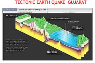
- Types of Earthquakes :
- The most common ones are the tectonic earthquakes. These are generated due to sliding of rocks along a fault plane.
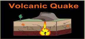
- A special class of tectonic earthquake is sometimes recognised as volcanic earthquake. However, these are confined to areas of active volcanoes.
- In the areas of intense mining activity, sometimes the roofs of underground mines collapse causing minor tremors. These are called collapse earthquakes.
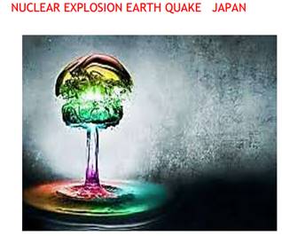
- Ground shaking may also occur due to the explosion of chemical or nuclear devices. Such tremors are called explosion earthquakes.
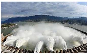
- The earthquakes that occur in the areas of large reservoirs are referred to as reservoir induced earthquakes.
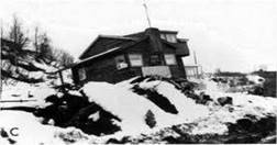
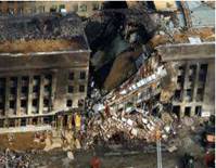
Effects of Earthquake: The effects of an earthquake can be devastating - they can destroy settlements, change landscapes, and cause many deaths.
- Ground shaking
- Damage to dams and reservoirs
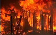
- Fire accidents
- Destruction to houses and buildings
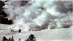
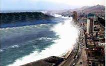
- Land slide and tsunami
- Soil liquefaction [solid soil becomes liquid]
- Destruction to transport and communication lines.
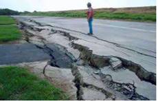
Earthquakes result in the formation of cracks and fissures on the ground formation:
- Earthquake causes dismantling of buildings, bridge and other structures at or near epicenter.
- Earthquakes result in the formation of cracks and fissures on the ground formation.
- Earthquakes originate sea waves called Tsunamis.
- Rails are folded, underground wires broken. Fire breaks out inevitably in large towns.
- Landslide due to earthquake may block valleys to form lakes.
- The earthquakes cause landslides and disturb the isostatic equilibrium.
Constructive Effects:
- Sometimes the earthquakes cause formation of hot springs which are very useful to people.
- Sometimes, the earthquakes cause emergence of costs and bring fertile shore out of water to give chance to develop crop production.
- Submergence of coastal land may result in formation of bays and gulfs which are favourable sites for the development of ports harbours.
- The earthquakes sometimes cause submergence in coastal land, and result in formation of inlets, bays and gulfs which help to develop of fishing and shipping etc.
- Earthquake may sometimes create new coastal plains, by the emergence of a portion of ocean floor.
- Earthquakes result in the formation of hot springs and geyser beneficial for medicinal purposes
Shadow Zones and Their Formation
Meaning of Shadow Zone: Earthquake waves get recorded in seismographs located at far off locations. However, there exist some specific areas where the waves are not reported. Such a zone is called the ‘shadow zone’.
Shadow zones are formed due to two reasons:
- Three layers in the earth
- Varying density of each layer
- Liquid condition of the mantle
- P Wave Shadow Zone: Ideally seismic waves should move in straight line but due to varying density of layer P wave moves in a curved path. Due to this an area around the earth does not record P wave. This zone is from 1050 to 1450 from the focus.
- S Wave Shadow Zone: It is larger zone than P wave shadow zone. It developed because S wave does not pass through liquid mantle of the earth. Therefore, the zone from 1050 all around the earth from the focus is called as S wave shadow zone.
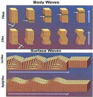
BODY WAVES GENERATED DUE TO ENERGY GENERATED IN THE EARTH’S INTERIOR
They interact with the surface rocks and generate other waves called surface waves.The velocity of the waves changes along with the density of material, denser the material higher the velocity
Their direction also changes according to the density of the material.
PROPAGATION OF EARTHQUAKE WAVES
When they travel in the body they vibrate the bodies of the rocks P waves vibrate parallel to their direction of the movement
It led to the density difference in the material due to stretching and squeezing Other three waves vibrate perpendicular to their direction
They create troughs and crests over the surface
EMERGENCE OF SHADOW ZONE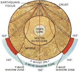
- Where earthquake waves are not reported, such zones are called earthquake shadow zones.
- It is observed that seismographs located beyond 103° from the epicenter do not record the earthquakes.
- The entire zone beyond 142° do not receive ‘s’ waves
- Seismographs located beyond 142° again record ‘p’ waves only.
- The shadow zone of ‘s’ waves is much larger than the ‘p’ waves it is equal to 40% of the earth surface
TYPES OF EARTHQUAKES
(INDONE)
(MINING EARTH QUAKE - SOUTH AFRI)
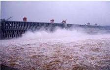
RESERVOIR IMPOUND EARTHQUAKE TEHRI DAM
HOW IS EARTH QUAKE MEASURED-RICHTER SCALE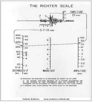
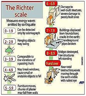
The magnitude of most earthquakes is measured on the Richter scale, invented by Charles F. Richter in 1934. The Richter magnitude is calculated from the amplitude of the largest seismic wave recorded for the earthquake, no matter what type of wave was the strongest.
The Richter magnitudes are based on a logarithmic scale (base 10). Using this scale, a magnitude 5 earthquake would result in ten times the level of ground shaking as a magnitude 4 earthquake (and 32 times as much energy would be released). To give you an idea how these numbers can add up, think of it in terms of the energy released by explosives: a magnitude 1 seismic wave releases as much energy as blowing up 6 ounces of TNT. A magnitude 8 earthquake releases as much energy as detonating 6 million tons of TNT. Pretty impressive, huh? Fortunately, most of the earthquakes that occur each year are magnitude 2.5 or less, too small to be felt by most people.
The Richter magnitude scale can be used to describe earthquakes so small that they are expressed in negative numbers. The scale also has no upper limit, so it can describe earthquakes of unimaginable and (so far) inexperienced intensity, such as magnitude 10.0 and beyond.
Although Richter originally proposed this way of measuring an earthquake's "size," he only used a certain type of seismograph and measured shallow earthquakes in Southern California. Scientists have now made other "magnitude" scales, all calibrated to Richter's original method, to use a variety of seismographs and measure the depths of earthquakes of all sizes.
First six listed above have some hearings upon landforms while others may be considered the effects causing immediate concern to the life and properties of people in the region.
Tsunami occurs when the epicenter is below the ocean floor with sufficient magnitude. Tsunamis are waves generated by the termers not by the earthquake. The magnitude should be more than 5 in Richter scale.
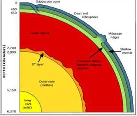
The earthquakes of magnitude 8+ are rare occurs once in 1 -2 years .tiny types occur every minute. The structure of the Earth
Imagine a Scotch egg :
- The outer shell of the Earth is called the CRUST (breadcrumbs)
- The next layer is called the MANTLE (sausage meat)
- The next layer is the liquid OUTER CORE (egg white)
- The middle bit is called the solid INNER CORE (egg yolk)
The deepest anyone has drilled into the earth is around 12 kilometers, we've only scratched the surface. How do we know what's going on deep underground?
There are lots of clues:
- The overall density of the Earth is much higher than the density of the rocks we find in the crust. This tells us that the inside must be made of something much denser than rock.
- Meteorites (created at the same time as the Earth, 4.6 billion years ago) have been analyzed. The commonest type is called a contrite and they contain iron, silicon, magnesium and oxygen (Others contain iron and nickel).
- Iron and Nickel are both dense and magnetic.
- Scientists can follow the path of seismic waves from earthquakes as they travel through the Earth. The inner core of the Earth appears to be solid whilst the outer core is liquid (s waves do not travel through liquids). The mantle is mainly solid as it is under extreme pressure (see below). We know that the mantle rocks are under extreme pressure, diamond is made from carbon deposits and is created in rocks that come from depths of 150-300 kilometers that have been squeezed under massive pressures.
- The Earth is sphere (as is the scotch egg!) with a diameter of about 12,700 Kilometers. As we go deeper and deeper into the earth the temperature and pressure rises. The core temperature is believed to be an incredible 5000-6000°c.
- The crust is very thin (average 20Km). This does not sound very thin but if you were to imagine the Earth as a football, the crust would be about ½ millimeter thick. The thinnest parts are under the oceans (OCEANIC CRUST) and go to a depth of roughly 10 kilometers.
The thickest parts are the continents (CONTINENTAL CRUST) which extend down to 35 kilometers on average. The continental crust in the Himalayas is some 75 kilometers deep. - The mantle is the layer beneath the crust which extends about half way to the centre. It's made of solid rock and behaves like an extremely viscous liquid - (This is the tricky bit... the mantle is a solid which flows????) The convection of heat from the center of the Earth is what ultimately drives the movement of the tectonic plates and cause mountains to rise.
- The inner core is the bit in the middle!. It is made of solid iron and nickel. Temperatures in the core are thought to be in the region of 5000- 6000° c and it's solid due to the massive pressure.
EARTH STRUCTURE
The crust the Outer most solid part :
- Brittle in nature
- Thickness is 5 km. thin under the oceans and thick under the continents
- 30 km under oceans and 70 km under mountains Desity in the ocean floor is 3g/cm3 (basait) mean density is 2.7g
The Crust: The Earth's crust is an extremely thin layer of rock that makes up the outermost solid shell of our planet. In relative terms, it's thickness is like that of the skin of an apple. It amounts to less than half of 1 percent of the planet's total mass but plays a vital role in most of Earth's natural cycles. The crust can be thicker than 80 kilometers in some spots and less than one kilometer thick in others. Underneath it lies the mantle, a layer of silicate rock approximately 2700 kilometers thick. The mantle accounts for the bulk of the Earth.The crust is composed of many different types of rocks that fall within three main categories: igneous,metamorphic, and sedimentary.
The mantle
- Second layer from the top of the earth
- The upper portion of the mantle is called ASTHENOSPHERE ( Astheno= weak it extends up to 400 km)
- It is the source of magma
- Average density is 3.4g/cm3
- It extends from Moho-discontinuity to a depth of 2900 km.
- Crust and upper most part of the mantle is called Lithosphere. Its thickness is 10 -200km
- Lower mantle is in solid state
The core :
- It extends from 2900 km to 6300 km depth
- Outer core is liquid while inner core is solid
- outer core density is 5 g/ inner core is 13 g/
- made of heavy metals such as Nickel and Iron
- it is also called as Nife
VOLCANOES AND VOLCANIC LANDFORMS
A volcano is a rupture in the crust of a planetary-mass object, such as Earth, that allows hot lava, volcanic ash, and gases to escape from a magma chamber below the surface. Earth's volcanoes occur because its crust is broken into 17 major, rigid tectonic plates that float on a hotter, softer layer in its mantle.A volcano is place where gases, ashes and or molten rock material lava escape to the ground.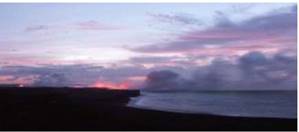
The Differences between Active, Dormant and Extinct volcanoes :
Active Volcano: An active volcano is a volcano that has had at least one eruption during the past 10,000 years. An active volcano might be erupting or dormant.Is a volcano that is currently erupting or shows signs of unrest activities, like earthquake activity or significant amounts of gas discharged. It is a volcano that is not presently erupting, but has erupted in the past is considered likely to do erupt in the future again. Mount Yasur, in Vanuatu, has been erupting "nearly continuously" for over 800 years.
One of the dormant volcanoes in the Cascades in the "Three Sister Area."
Dormant: Dormant volcanos are the volcanoes that are quiet, but might possibly erupt again. A dormant volcano is "sleeping," but it could awaken in the future. Dormant volcanos include those which have not erupted in the past 10,000 years. In other words, these volcanoes are also called "Sleeping" volcanoes because it is presently inactive, but could erupt again. For example, the majority of the Cascade volcanoes are believed to be dormant rather than extinct.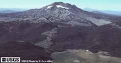
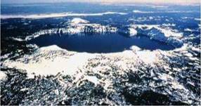
This is an Aerial view of Crater Lake in Oregon.
Extinct: An extinct volcano has not had an eruption for at least 10,000 years and is not expected to erupt again in a comparable time scale of the future. In other words, it is a volcano that is presently not erupting, that is unlikely to do so for a very long time in the future. Examples of extinct volcanoes: Kilimanjaro (Tanzania), Mt Warning (Australia), Chaine des Puys (France),
Elbrus (Russia).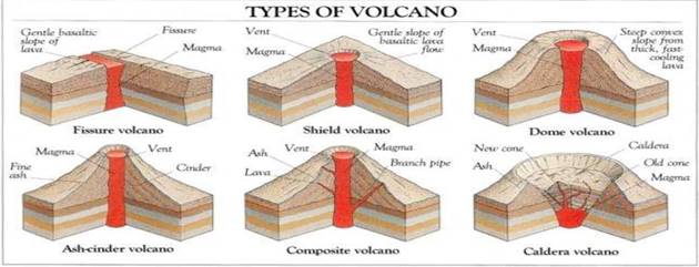
Classification of volcanoes based on nature of eruption and land forms developed on the surface. SHIELD VOLCANO: A shield volcano is a type of volcano usually built almost entirely of fluid lava flows. They are named for their low profile, resembling a warrior's shield lying on the ground. This is caused by the highly fluid lava they erupt which travels farther than lava erupted from stratovolcanoes.
- Largest of volcanoes
- Hawaiian islands are best examples
- They become explosive when water is held in tovent
- Develops in to cinder cone
- Basalt lava flow
- Lava is very fluid
- They are not steep
COMPOSITE VOLCANOES:
These volcanoes are characterised by eruptions of cooler and more viscous lavas than basalt. These volcanoes often result in explosive eruptions. Along with lava, large quantities of pyroclastic material and ashes find their way to the ground. This material accumulates in the vicinity of the vent openings leading to formation of layers, and this makes the mounts appear as composite volcanoes
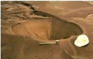
CALDERA: These are the most explosive of the earth’s volcanoes. They are usually so explosive that when they erupt they tend to collapse on themselves rather than building any tall structure. The collapsed depressions are called calderas. Depending on their intensity and duration, volcanic eruptions can create calderas as much as 100 kilometers (62 miles) wide.
- These are the most explosive type of volcanoes
- They collapse the selves and form into lakes
- The magma chamber is huge and found nearby
FLOOD BASALT PROVINCES
These volcanoes outpour highly fluid lava that flows for long distances. Some parts of the world are covered by thousands of sq. km of thick basalt lava flows.Ex. Deccan plateau. It is believed that initially the trap formations covered a much larger area than the present.
MID OCEANIC RIDGES VOLCANOES
These volcanoes occur in the oceanic areas. There is a system of mid-ocean ridges more than 70,000 km long that stretches through all the ocean basins. The central portion of this ridge experiences frequent eruptions.
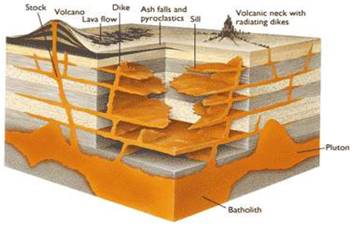
INTRUSIVE VOLCANIC LANDFORMS
- when volcanic eruption takes place some lava comes out and some settle down in the lithosphere.
- when lava comes out forms volcanic rocks, some part cools down in the lower portion forms plutonic rocks
INTRUSIVE FORMS OCCUR INSIDE THE CRUST.
BATHOLITH: These are large rock masses formed due to cooling down and solidification of hot magma inside the earth. They appear on the surface only after the denudation processes remove the overlying materials. Batholiths form the core of huge mountains and may be exposed on surface after erosion. These are granitic. A large part of the magma material that cools in the deeper depthof the crust. They are dome shaped, cover large areas,
They come out when erosion takes place.they are granite bodies.
- LACCOLITHS: A laccolith is a sheet intrusion (or concordant pluton) that has been injected between two layers of sedimentary rock. The pressure of the magma is high enough that the overlying strata are forced upward, giving the laccolith a dome or mushroom-like form with a generally planar base. Large dome shaped intrusive bodies. Consists of level bodies Connected through pipe like conduit from below it resembles composite volcanoes found deeper depths they are localised source of lava Ex. Karnataka plateau
- LAPOLITHS: A lopolith is a large igneous intrusion which is lenticular in shape with a depressed central region. Lopoliths are generally concordant with the intruded strata with dike or funnel-shaped feeder bodies below the body. Concave shaped lava formation phacoliths: wave typed lava formation
- SILL: A sill is a tabular sheet intrusion that has intruded between older layers of sedimentary rock, beds of volcanic lava or tuff, or even along the direction of foliation in metamorphic rock. The term sill is synonymous with concordant intrusive sheet. Horizontal sheet of lava
- DYKES: A dyke (or dike) in geology is a type of later vertical rock between older layers of rock. Technically, it is any geologic body which cuts across: flat wall rock structures, such as bedding. massive rock formations, usually igneous in origin. Vertical lava formation.
