India-Location - Revision Notes
CBSE Class 11 Geography
Chapter-1 India - Location
This unit deals with
- Location - spatial relations and India’s place in the world
Facts of India
| India facts | |
| Territorial Sea | 12 nm (nautical miles) |
| Contiguous Zone | 24 nm |
| Exclusive economic Zone | 200 nm |
| Continental Shelf | 200 nm or to the edge of the continental margin |
| Longest River | Ganga |
| Largest Lake | Lake Chilka |
| Highest Point | Mt. K2 (8611 m) |
| Highest Point of Himalaya | Kanchan Junga (8,598m) |
| Lowest Point | Kuttanad (-2.2 m) |
| Northernmost Point | Siachen Glacier near Karakoram |
| Southernmost Point | Indira Point, Great Nicobar, Andaman & Nicobar Islands |
| Southernmost Point of India (Mainland) | Cape Comorin (Kanya Kumari) |
| Westernmost Point | West of Ghuar Mota, Gujarat |
| Easternmost Point | Kibithu, Arunachal Pradesh |
| Highest Altitude | Kanchenjunga, Sikkim |
| Lowest Altitude | Kuttanad (Kerala) |
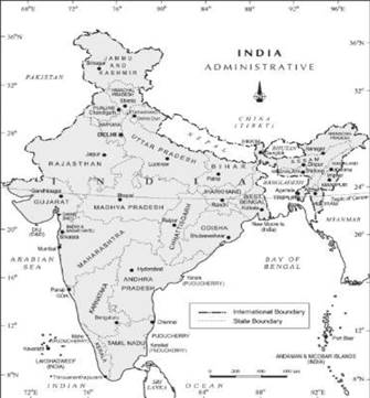
The mainland of India, extends from Kashmir in the north to Kanyakumari in the south and Arunachal Pradesh in the east to Gujarat in the west. India‘s territorial limit further extends towards the sea up to 12 nautical miles (about 21.9 km) from the coast. Our southern boundary extends up to 6°45' N latitude in the Bay of Bengal. Let us work out implications of having such a vast longitudinal and latitudinal extent The latitudinal and longitudinal extent of India are roughly about 30 degrees, whereas the actual distance measured from north to south extremity is 3,214 km, and that from east to west is only 2,933 km.This difference is based on the fact that the distance between two longitudes decreases towards the poles whereas the distance between two latitudes remains the same everywhere.
Find out the distance between two latitudes?
From the values of latitude, it is understood that the southern part of the country lies within the tropics and the northern part lies in the sub-tropical zone or the warm temperate zone. This location is responsible for large variations in land forms, climate, soil types and natural vegetation in the country. From the values of longitude, it is quite discernible that there is a variation of nearly 30 degrees, which causes a time difference of nearly two hours between the easternmost and the westernmost parts of our country. While the sun rises in the northeastern states about two hours earlier as compared to Jaisalmer, the watches in Dibrugarh, Imphal in the east and Jaisalmer, Bhopal or Chennai in the other parts of India show the same time.
Why does this happen?
There is a general understanding among the countries of the world to select the standard meridian in multiples of 7°30' of longitude. That is why 82°30' E has been selected as the ‘standard meridian’ of India. Indian Standard Time is ahead of Greenwich Mean Time by 5 hours and 30 minutes.
There are some countries where there are more than one standard meridian due to their vast east-to-west extent. For example, the USA has seven time zones.
Name a few places in India through which the standard meridian passes :
- ALLAHABAD
- KAKINADA
SIZE : Total area of India is 32, lakh sq. km 7th largest country with 2.4 % of total land area of the world Indian subcontinent.
It includes the countries Pakistan, Nepal, Bhutan, Bangladesh and India.
Coastline length is 7516.5 km land frontier area is 15200 km.
INDIA AND ITS NEIGHBOURS :
- Myanmar
- Bangladesh
- Sri Lanka
- Maldives.
- Pakistan
- China
- Nepal
- Bhutan
Sri Lanka is separated from India by the Gulf of Mannar and Palk Strait.
