Distribution of Oceans - Revision Notes
Class 11 Geography
Chapter-4 Distribution of Oceans and Continent
GIST OF THE LESSON:
- Continental Drift,
- Evidences to support continental drift,
- Forces of drifting,
- Post drift studies,
- Ocean floor configuration,
- Distribution of volcanoes and earthquakes,
- Concept of sea floor spreading,
- Plate tectonics,
- Major and minor plates,
- Types of plate boundaries rates of plate movement,
- Forces of plate movement & movement of the Indian plate.
CONTINENTAL DRIFT: Continental drift was a theory that explained how continents shift position on Earth's surface. ABRAHAM ORTELIUS a Duchy map maker 1596 first proposed the possibility of joining the continents such as America with Europe and Africa ANTONIO PEREGRINE drew the map showing the three continents together.
- Alfred Wegener a German meteorologist put forth THE CONTINENTAL DRIFT THEORY. According to him,
- All continents formed a single continental mass called PANGAEA
- All oceans formed a single universal ocean called PANTHALASSA
- AROUND 200 mya THE PANGAEA BEGAN TO SPLIT INTO TWO LARGE MASSES CALLED LAURASIA and GONDWANA LAND
- By further splitting Laurasia formed northern continents and Gondwana land formed southern continents.
EVIDENCES TO SUPPORT THE CONTINENTAL DRIFT
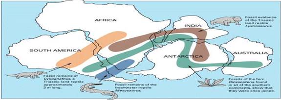
- The matching of continents (jig-saw fit)
The shorelines of S. America and Africa have remarkable match.It was a map that produced by Bullard in 1964 to show the jigsaw fit of these two continents.It was fit around 1000 fathom line of the shoreline.The Atlantic coasts of Africa and South America appear to fit together neatly, like the pieces of a jigsaw puzzle.
- ROCKS OF SAME AGE ACROSS THE OCEANS: Wegener discovered that identical rocks could be found on both sides of the Atlantic Ocean.These rocks were the same type and the same age. Wegener understood that the rocks had formed side-by-side and that the land has since moved apart. The belt of ancient rocks of 2,000 million years from Brazil coast matches with those from western Africa. The earliest marine deposits along the coastline of South America and Africa are of the Jurassic age. but that are now on opposite sides of the Atlantic Ocean. The Appalachians of the eastern United States and Canada, for example, are just like mountain ranges in eastern Greenland, Ireland, Great Britain, and Norway. Wegener concluded that they formed as a single mountain range that was separated as the continents drifted.
- TILLITE: It is the sedimentary rock formed out of deposits of glaciers.. At the base the system has thick tillite indicating extensive and prolonged glaciation.
- Sediments from India have similar counter parts at different continents of south.
- The same glaciations is found in Africa, Falklands, Madagascar, Antarctica and Australia
- The glacial tillite indicates that unambiguous evidence of palaeo climates and drifting of continents.
- PLACER DEPOSITS: In geology, a placer deposit or placer is an accumulation of valuable minerals formed by gravity separation during sedimentary processes.
- Formation of placer deposits of gold in Ghana coast has no source rock.
- The gold bearing veins of rocks are found in Brazil
- DISTRIBUTION OF FOSSILS: Fossils are the preserved traces of animals or plants found inside rock. They are useful in dating geological material, because they indicate which species were alive at the time the rock was formed.
- Identical species of animals and plants are found along the coastal regions of the different continents.
- LEMURIA: The observations that Lemurs occur in India, Madagascar and Africa led some to consider a contiguous landmass “Lemuria” linking these three landmasses.

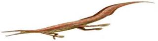
- MESOSAURUS : Mesosaurus was a small reptile adapted to shallow brackish wate
- DISTRIBUTION OF FOSSILS
FORCES FOR DRIFTING THE CONTINENTS
- Wegner suggested that the movement responsible for the drifting of the continents was caused by:
- A.)POLAR FLEEING FORCE :The polar-fleeing force relates to the rotation of the earth. This bulge is due to the rotation of the earth.
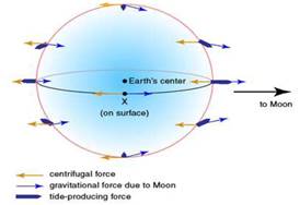
- B.)TIDAL FORCE: The Tidal force is due to the attraction of the moon and the sun that develops tides in oceanic waters. It arises because the gravitational force exerted by one body on another is not constant across it: the nearest side is attracted more strongly than the farthest side.
- Possible driving forces for plate tectonics:
- Bottom lithosphere tractions by convection currents.
- Trench suck (rollback).
- Global expanding or contracting forces.
- Trench pull (covered earlier).
- Ridge push (sliding off a high, crust in compression).
- Membrane forces on spinning ellipsoid (e.g. variants of polar fleeing forces).
POST DRIFT STUDIES :
Information collected from the ocean mapping is more useful to study the continental drift.
Convectional current theory:It was proposed by ARTHUR HOLMES IN 1930 Due to difference in the temperature currents are formed due to disintegration of radioactive materials inside the earth. Convection currents in the magma drive plate tectonics. Heat generated from the radioactive decay of elements deep in the interior of the Earth creates magma (molten rock) in the aesthenosphere. The aesthenosphere (70 ~ 250 km) is part of the mantle, the middle sphere of the Earth that extends to 2900 km.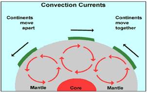
These currents are found entire mantle portion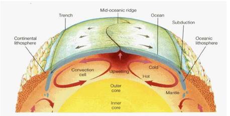
MAPPING OCEAN FLOOR: The surface area of the Earth, as a whole, is dominated by the ocean basins. As part of a continuous worldwide process, new ocean crust forms at ocean ridges and is destroyed in the deep ocean trenches. Despite its dominance, the ocean floor is largely unexplored and unmapped.
- Existence of ridges and deep trenches nearby continental margins
- Mid oceanic ridge is the most active for volcanic eruptions
- The ocean floor is much younger than the continents
- Rocks of equal distance of the ridge have similar chemical composition and age
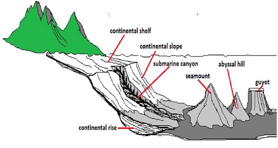
OCEAN FLOOR CONFIGURATION: The current spatial configuration of the ocean basins is a by product of plate tectonics. The creation of new oceanic crust at the mid-oceanic ridge moves the continents across the Earth's surface and creates zones of subduction. The ocean floor may be segmented into three major divisions based on the depth as well as the forms of relief. These divisions are continental margins, deep-sea basins and mid-ocean ridges.
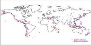
DISTRIBUTION OF VOLCANOES AND EARTHQUAKES: Plate tectonics cause earthquakes and volcanoes. The point where two plates meet is called a plate boundary. Earthquakes and volcanoes are most likely to occur either on or near plate boundaries.
- all volcanoes and earthquakes are paralle to the coast
- this line also coinsides with mid- atalantic ridge
- alpine hymalayan system
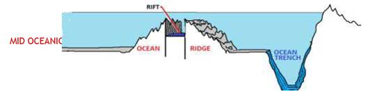
- around the pacific ocean it is called ring of fire Mid oceanic ridges
- Interconnected mountain system within the ocean
- Longest mountain chain in the ocean floor
- Consist of central rift system at the crust
- Intense volcanic activity is found
CONCEPT OF SEA FLOOR SPREADING: Seafloor spreading is a process that occurs at mid-ocean ridges, where new oceanic crust is formed through volcanic activity and then gradually moves away from the ridge. Seafloor spreading helps explain continental drift in the theory of plate tectonics.
- It was proposed by Hess in 1961
- He believed that new lava pushes out the plates from the mid oceanic ridge
- Palaeo magnetic studies of the ocean floor reveals that
- Along the mid oceanic ridge there is intense volcanic eruption
- Oceanic crust is much younger(200my) than continental crust (3200my)
- The sediments of ocean floor is very thins
- Huge amount of lava comes out along the mid atlanticn ridges
- The equidistant rock formations have similar age and chemical compositions & magnetic properties
- Rocks closer to the mid oceanic ridges are young and normal polarity
- The age of rocks increases as the distance increases from the mid oceanic ridge
- Earth quakes are common along the deep sea trenches Positions of continents through geological past
PLATE TECTONICS: Plate tectonics is the theory that Earth's outer shell is divided into several plates that glide over the mantle, the rocky inner layer above the core.The theory of plate tectonics was introduced by McKenzie, parker and Morgan in 1967.The plates act like a hard and rigid shell compared to Earth's mantle. This strong outer layer is called the lithosphere. It is a massive irregularly shaped slab of solid rock. Plates move horizontally over the Asthenosphere. Average thickness is 100 km of oceanic part and 200 km continental part. Pacific plate is largest oceanic plate where as Eurasian plate is the largest continental plate.
MAJOR PLATES OF THE EARTH CRUST
MAJORPLATES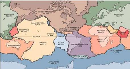
MAJOR PLATES
- Antarctica And Surrounding Oceanic Plate
- North American Plate
- South American Plate
- Pacific Plate
- India-Australia-New Zealand PLATE
- African Plate Eurasian Plate
MINOR PLATES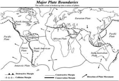
- Cocos Plate
- Nazca Plate
- Arabian Plate
- Philippine Plate
- Caroline Plate
- Fuji Plate
These plates are moving constantly throughout geological time not the continent believed by Wegener Pangaea was the convergent of all the plates
Position of Indian subcontinent is traced with the help of rocks analyzed from Nagpur area
TYPES OF PLATE BOUNDARIES
I. DIVERGENT BOUNDARIES: In plate tectonics, a divergent boundary or divergent plate boundary (also known as a constructive boundary or an extensional boundary) is a linear feature that exists between two tectonic plates that are moving away from each other.
- New crust is generated plates move away from each other
- These are called spreading sites
- Ex. Mid Atlantic ridge
II. CONVERGENT BOUNDARY: In plate tectonics, a convergent boundary, also known as a destructive plate boundary, is a region of active deformation where two or more tectonic plates or fragments of the lithosphere near the end of their life cycle.
- Crust is destroyed
- sinking of plate is called ‘subduction zone’
- There are three ways in which subduction occurs
Ocean and continent ii. Ocean and ocean iii. continent and continent plates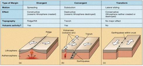
III TRANSFORM BOUNDARIES: A transform fault or transform boundary (also known as a conservative plate boundary, since these faults neither create nor destroy lithosphere), is a type of fault whose relative motion is predominantly horizontal, in either a sinistral (left lateral) or dextral (right lateral) direction.
- Crust is neither produced nor destroyed
- Plates slide horizontally
- Perpendicular to the mid oceanic ridges
- Differential movement of a plate at the same time
- Rotation of the earth has its effect on this movement
RATES OF PLATE MOVEMENT: Some sources state that in the North Atlantic, the rate of movement is only about 1 cm (about 0.4 in) per year, while in the Pacific it amounts to more than 4 cm (almost 2 in) annually, while others say that plates, in general, travel from 5 to 10 cm/yr.
- The strips of normal and reverse magnetic field helped the scientists to study the rate of plate movement
- Arctic ridge has the slowest rate less than 2.5 cm /year east pacific rise has more than
- 15 cm/year
FORCES OF THE PLATE MOVEMENT: For much of the last quarter century, the leading theory of the driving force behind tectonic plate motions envisaged large scale convection currents in the upper mantle, which can be transmitted through the asthenosphere.
- Surface of the earth is dynamic
- Interior is always mobile
- Beneath the lithosphere there is always movement of magma horizontally
- Heated material rises to the top and cooled material sinks down
- This cycle is repeated over the time and form convection cells
SOURCES OF HEAT: A heat source is anything that can heat up a spacecraft. Heat sources can be external (from outside the spacecraft) or internal (from inside the spacecraft). External heat sources include: the Sun. reflected sunlight from planets and moons.
- Residual heat: Heat that remains or lingers after something has been hot or heated up. Turn the hotplate off and allow the residual heat to keep the mixture simmering.
- Radioactive decay: Radioactive decay (also known as nuclear decay or radioactivity) is the process by which an unstable atomic nucleus loses energy (in terms of mass in its rest frame) by emitting radiation, such as an alpha particle, beta particle with neutrino or only a neutrino in the case of electron capture, gamma ray, electron in the case of internal conversion.
MOVEMENT OF INDIAN PLATE: The Indian Plate or India Plate is a major tectonic plate straddling the equator in the eastern hemisphere. Originally a part of the ancient continent of Gondwana, India broke away from the other fragments of Gondwana 100 million years ago and began moving north.The Indian tectonic plate is located in the north east hemisphere. It is bounded by 4 major tectonic plates. North of the Indian plate is the Eurasian plate, to the south east, the Australian plate, to the south west, the African plate and to the west the Arabian plate.
- Indian plate includes India and Australia
- Northern boundary is along the Himalayas
- It is the place of continental convergence
- In the east it extends up to Rakinyoma mountains of Myanmar
- Eastern margin is spreading site
- Western margin extends along Kirthar mountains, Makran coast red sea rift.
- The boundary between India and Antarctica is called divergent boundary
- Till 225 m y a India was separated by Tethys sea
- About 200 m y a India started its journey towards north
- India collided with Asia about 40-50 m y a and caused the upliftment of Himalayas
- About 140 m y a the position of Indian plate is at 50°s latitude
- During the movement of Indian plate two events occurred in India
- A. out pouring of lava and formation of Deccan plateau
B. Subsidence of west coast - The Himalayas started rising about 40 m y a
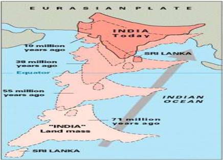
STAGES OF MOVEMENT OF INDIAN PLATE TO WARDS ASIAN PLATE AT DIFFERENT AGES
