Atmospheric Circulation - Solutions
CBSE Class 11 Geography
NCERT Solutions
Chapter 10
Atmospheric Circulation And Weather Systems
1. Multiple choice questions.
(i) If the surface air pressure is 1,000 mb, the air pressure at 1 km above the surface will be:
(a) 700 mb
(b) 1,100 mb
(c) 900 mb
(d) 1,300 mb.
Ans. (c) 900 mb
(ii) The Inter Tropical Convergence Zone normally occurs:
(a) Near the Equator
(b) Near the Tropic of Cancer
(c) Near the Tropic of Capricorn
(d) Near the Arctic Circle.
Ans. (a) Near the Equator
(iii) The direction of wind around a low pressure in northern hemisphere is:
(a) Clockwise
(b) Perpendicular to isobars
(c) Anti-clock wise
(d) Parallel to isobars.
Ans. (c) Anti-clock wise
(iv) Which one of the following is the source region for the formation of air masses?
(a) The Equatorial Forest
(b) The Himalayas
(c) The Siberian Plain
(d) The Deccan Plateau.
Ans. (c) The Siberian plains.
2. Answer the following questions in about 30 words.
(i) What is the unit used in measuring pressure? Why is the pressure measured at station level reduced to the sea level in preparation of weather maps?
Ans. Millibar or Pascal is the unit for measuring pressure. Most widely used unit is kilo Pascal expressed as hpa. Horizontal distribution of pressure is studied by drawing isobars at constant levels. Isobars are lines connecting places having equal pressure. Due to gravity the air at the surface is denser and hence has higher pressure. Air pressure is measured with the help of a mercury barometer or the aneroid barometer. In order to eliminate the effect of altitude on pressure, it is measured at any station after being reduced to sea level for making it comparative. The pressure measured at station level is reduced to the sea level in preparation of weather maps. Mall differences in pressure are highly significant in terms of the wind direction and velocity. Horizontal distribution of pressure is studied by drawing isobars at constant levels. Isobars are lines connecting places having equal pressure. In order to eliminate the effect of altitude on pressure, it is measured at any station after being reduced to sea level for purposes of comparison.
(ii) While the pressure gradient force is from north to south, i.e. from the subtropical high pressure to the equator in the northern hemisphere, why are the winds north easterlies in the tropics?
Ans. Rotation of the earth also affects the wind movement. The force exerted by the rotation of the earth is known as the Coriolis force. Due to this effect, winds move to the right from their original direction in northern hemisphere and to the left in the southern hemisphere. The deflection is more when the wind velocity is high. The Coriolis force is directly proportional to the angle of latitude. It is maximum at the poles and is absent at the equator. The Coriolis force acts perpendicular to the pressure gradient force. The pressure gradient force is perpendicular to an isobar. The higher the pressure gradient force, the more is the velocity of the wind and the larger is the deflection in the direction of wind. As a result of these two forces operating perpendicular to each other, in the low-pressure areas the wind blows around it. Therefore, when pressure gradient force is from south to north then winds move from south to north easterlies.
(iii) What are the geotrophic winds?
Ans. The geostrophic wind is the theoretical wind that would result from an exact balance between the Coriolis Force and the pressure gradient force. This condition is called geostrophic balance. The velocity and direction of the wind are the net result of the wind generating forces. The winds in the upper atmosphere, 2 - 3 km above the surface, are free from frictional effect of the surface and are controlled mainly by the pressure gradient and the Coriolis force. When isobars are straight and when there is no friction, the pressure gradient force is balanced by the Coriolis force and the resultant wind blows parallel to the isobar. This wind is known as the geostrophic wind. An air parcel initially at rest will move from high pressure to low pressure because of the pressure gradient force. However, as that air parcel begins to move, it is deflected by the Coriolis force to the right in the northern hemisphere (to the left on the southern hemisphere). As the wind gains speed, the deflection increases until the Coriolis force equals the pressure gradient force. At this point, the wind will be blowing parallel to the isobars. When this happens, the wind is referred to as geostrophic.
(iv) Explain the land and sea breezes.
Ans. A sea breeze or onshore breeze is any wind that blows from a large body of water toward or onto a landmass; it develops due to differences in air pressure created by the differing heat capacities of water and dry land. As such, sea breezes are more localised than prevailing winds. Because land absorbs solar radiation far more quickly than water, a sea breeze is a common occurrence along coasts after sunrise. During the day the land heats up faster and becomes warmer than the sea. Therefore, over the land the air rises giving rise to a low pressure area, whereas the sea is relatively cool and the pressure over sea is relatively high. Thus, pressure gradient from sea to land is created and the wind blows from the sea to the land which is known as sea breeze. By contrast, a land breeze or offshore breeze is the reverse effect: dry land also cools more quickly than water and, after sunset, a sea breeze dissipates and the wind instead flows from the land towards the sea. Sea breezes and land breezes are both important factors in coastal regions' prevailing winds.
3. Answer the following questions in about 150 words.
(i) Discuss the factors affecting the speed and direction of wind.
Ans. Wind speed, or wind flow velocity, is a fundamental atmospheric quantity. Wind speed is caused by air moving from high pressure to low pressure, usually due to changes in temperature. Wind speed affects weather forecasting, aircraft and maritime operations, construction projects, growth and metabolism rate of many plant species, and countless other implications. Wind speed is now commonly measured with an anemometer but can also be classified using the older Beaufort scale which is based on people's observation of specifically defined wind effects. Air is set in motion due to the differences in atmospheric pressure. The air in motion is called wind, which blows from high pressure to low pressure. The wind at the surface experiences friction. In addition, rotation of the earth also affects the wind movement. The force exerted by the rotation of the earth is known as the Coriolis force. Thus, the horizontal winds near the earth surface respond to the combined effect of three forces - the pressure gradient force, the frictional force and the Coriolis force. In addition, the gravitational force acts downward.
(a) Pressure gradient force: In atmospheric sciences (meteorology, climatology and related fields), the pressure gradient is a physical quantity that describes which direction and at what rate the pressure changes the most rapidly around a particular location. The differences in atmospheric pressure produce a force. The rate of change of pressure with respect to distance is the pressure gradient. The pressure gradient is strong where the isobars are close to each other and is weak where the isobars are apart.
(b) Frictional force: Friction is the force resisting the relative motion of solid surfaces, fluid layers, and material elements sliding against each other. There are several types of friction: Dry friction is a force that opposes the relative lateral motion of two solid surfaces in contact. It affects the speed of the wind. It is greatest at the surface and its influence generally extends upto an elevation of 1 - 3 km. Over the sea surface the friction is minimal.
(c) Coriolis force: Coriolis Force an artefact of the earth's rotation. Once air has been set in motion by the pressure gradient force, it undergoes an apparent deflection from its path, as seen by an observer on the earth. This apparent deflection is called the "Coriolis force" and is a result of the earth's rotation. The rotation of the earth about its axis affects the direction of the wind. This force is called the Coriolis force. It deflects the wind to the right direction in the northern hemisphere and in nature. They oscillate with the apparent movement of the sun. In the northern hemisphere in winter they move southwards and in the summer northwards.
(ii) Draw a simplified diagram to show the general circulation of the atmosphere over the globe. What are the possible reasons for the formation of subtropical high pressure over 30° N and S latitudes?
Ans. The general circulation of the atmosphere also sets in motion the ocean water circulation which influences the earth's climate. The general circulation of the atmosphere also affects the oceans. The large-scale winds of the atmosphere initiate large and slow moving currents of the ocean, which in turn provide input of energy and water vapour into the air. These interactions take place rather slowly over a large part of the ocean. The air at the Inter Tropical Convergence Zone (ITCZ) rises because of convection caused by high
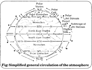
insolation and a low pressure is created. The winds from the tropics converge at this low pressure zone. The converged air rises along with the convective cell. It reaches the top of the troposphere up to an altitude of 14 km. and moves towards the poles. This causes accumulation of air at about 30° N and S. Part of the accumulated air sinks to the ground and forms a subtropical high. Another reason for sinking is the cooling of air when it reaches 30° N and S latitudes. The subtropical ridge, also known as the subtropical high or horse latitudes, is a significant belt of atmospheric high pressure situated around the latitudes of 30°N in the Northern Hemisphere and 300S in the Southern Hemisphere. It is the product of the global air circulation cell known as the Hadley Cell.
(iii) Why does tropical cyclone originate over the seas? In which part of the tropical cyclone do torrential rains and high velocity winds blow and why?
Ans. Tropical Cyclones are low pressure systems that form over warm tropical waters. Tropical cyclones derive their energy from the warm tropical oceans and do not form unless the sea-surface temperature is above 26.5°C, although once formed, they can persist over lower sea-surface temperatures. Tropical cyclones can persist for many days and may follow quite erratic paths. They usually dissipate over land or colder oceans. At the equator, the Coriolis force is zero and the wind blows perpendicular to the isobars. The low pressure gets filled instead of getting intensified. That is the reason why tropical cyclones are not formed near the equator.
Intensive Rainfall occurs to the left of the Cyclone. Maximum rainfall occurs close to the centre of the storm. Secondary maximum of rainfall occurs 2º away from Primary maximum to the right of the storm centre. Slow moving/big size cyclones give more rainfall, whereas, fast
moving/small size ones give less rainfall. More than 90% of rainfall is limited within 200 Km radius of the storm. Torrential rain occurs in the eye of the cyclone. The strong spirally circulating wind around the centre is called the eye. The diameter of the circulating system can vary between 150 and 250 km. The eye is a region of calm with subsiding air. Around the eye is the eye wall, where there is a strong spiralling ascent of air to greater height reaching the tropopause. The wind reaches maximum velocity in this region, reaching as high as 250 km per hour. From the eye wall rain bands may radiate and trains of cumulus and cumulonimbus clouds may drift into the outer region.
Due to torrential rain, wind blowing from those regions are humid. It brings precipitation in oceanic regions. Due to torrential rains, heavy rain takes place on eastern coast of India and north east coast of China.
