Atmospheric Circulation - Revision Notes
Class 11 Geography
Chapter-10 Atmospheric Circulation and Weather System
This chapter deals with : Atmospheric pressure,
- vertical variation pressure,
- horizontal distribution of pressure,
- world distribution of sea level pressure,
- factors affecting the velocity and direction of wind( pressure gradient force),
- frictional force, carioles force, pressure and wind),
- general circulation of the atmosphere,
- ENSO seasonal wind,
- local winds land and sea breezes mountain and valley winds,
- air masses , fronts, exratropical cyclone tropical cyclones, thunderstorms, tornadoes.
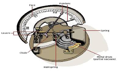
The weight of a column of air contained in a unit area from the mean sea level to the top of the atmosphere is called the atmospheric pressure. The atmospheric pressure is expressed in units of milibar. At sea level the average atmospheric pressure is 1,013.2 milibar. Due to gravitythe air at the surface is denser and hence has higher pressure. Air pressure is measured with the help of a mercury barometer or the aneroid barometer.
The pressure decreases with height. At any elevation it varies from place to place and its variation is the primary cause of air motion, i.e. wind which moves from high pressure areas to low pressure areas.
Vertical Variation of Pressure
In the lower atmosphere the pressure decreases rapidly with height. The decrease amounts to about 1mb for each 10 m increase in elevation.Table 10.1 gives the average pressure and temperature at selected levels of elevation for a standard atmosphere.
Table 10.1: Standard Pressure and Temperature at Selected Levels :
| Level | Pressure in mb | Tempemtiare oC |
| Sea Level | 1.013.25 | 15.2 |
| 1 km | 898.76 | 8.7 |
| 5 km | 540.48 | -17. 3 |
| 10 km | 265 | -49.7 |
The verticals pressure gradient force is much larger than of the horizontal pressure gradient.
But, it is generally balanced by a nearly equal but opposite gravitational force.
Horizontal Distribution of Pressure :
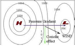
Horizontal distribution of pressure is studied by drawing isobars at constant levels. Isobars are lines connecting places having equal pressure. In order to eliminate the effect of altitude on pressure, it is measured at any station after being reduced to sea level for purposes of comparison.The sea level pressure distribution is shown on weather maps. Figure 10.1 shows the patterns of isobars corresponding to pressure systems. Lowpressure system is enclosed by one or more isobars with the lowest pressure in the centre. High-pressure system is also enclosed by one or more isobars with the highest pressure in the centre.
World Distribution of Sea Level Pressure :
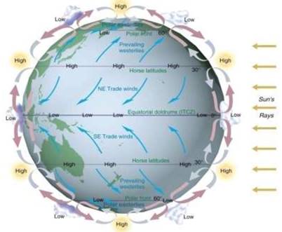
The world distribution of sea level pressure in January and July has been shown in Figures 10.2 and 10.3. Near the equator the sea level pressure is low and the area is known as equatorial low.
Along 30° N and 30 °S found the high-pressure areas known as the subtropical highs.
Further pole wards along 60°N and 60°S, the low-pressure belts are termed as the sub polar lows. Near the poles the pressure is high and it is known as the polar high.
These pressure belts are not permanent in nature.
Forces Affecting the Velocity and Direction of Wind :
- The air is set in motion due to the differences in atmospheric pressure.
- The air in motion is called wind. The wind blows from high pressure to low pressure, addition, rotation of the earth also affects the wind movement.
- The force exerted by the rotation of the earth is known as the Coriolis force.
- The horizontal winds near the earth surface respond to the combined effect of three forces - the pressure gradient force, the frictional force and the Carioles’ force. In addition, the gravitational force acts downward.
Pressure Gradient Force :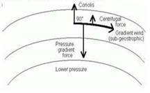
The differences in atmospheric pressure produces a force. The rate of change of pressure with respect to distance is the pressure gradient. The pressure gradient is strong.
• Frictional Force: It affects the speed of the wind. It is greatest at the surface and its influence generally extends up to an elevation of 1 - 3 km.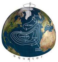
Coriolis Force :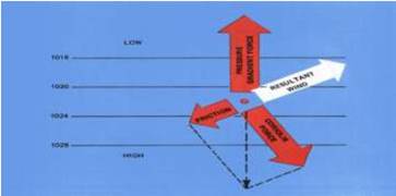
The rotation of the earth about its axis affects the direction of the wind. This force is called the Coriolis force after the French physicist who described it in 1844. It deflects the wind to the right direction in the northern hemisphere and to the left in the southern hemisphere.The deflection is more when the wind velocity is high. The Coriolis force is directly proportional to the angle of latitude. It is maximum at the poles and is absent at the equator.The pressure gradient force is perpendicular to an isobar. The higher the pressure gradient force, the more is the velocity of the wind and the larger is the deflection in the direction of wind. As a result of these two forces operating perpendicular to each other, in the low-pressure areas the wind blows around it. The low pressure gets filled instead of getting intensified. That is the reason why tropical cyclones are not formed near the equator.
Pressure and Wind : The velocity and direction of the wind are the net results of the wind generating the upper atmosphere, 2 – 3 km above the from frictional effects of the surface and are the pressure gradient of the Coriolis force.
Geostrophic wind : Straight and when there is no friction, the pressure gradient force is Coriolis force and the resultant wind blows. This wind is known as the geostrophic wind.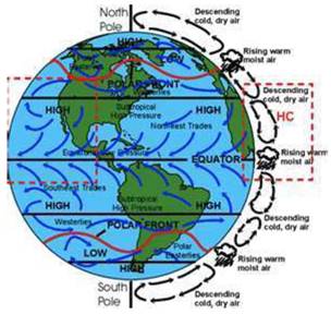
Pressure and Wind
The velocity and direction of the wind forces. The winds in surface, are free controlled mainly by when isobars are balanced by the parallel to the isobar.
Figure 10.4: Geostrophic Wind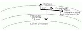
Cyclonic circulation : The wind circulation around a low is called cyclonic circulation.
The direction of winds around such systems changes according to their location in different hemispheres (Table 10.2).
The wind circulation at the earth’s surface closely related to the wind circulation at higher level. Over high pressure area the air will subside from above and diverge at the surface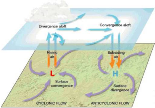
General circulation of the atmosphere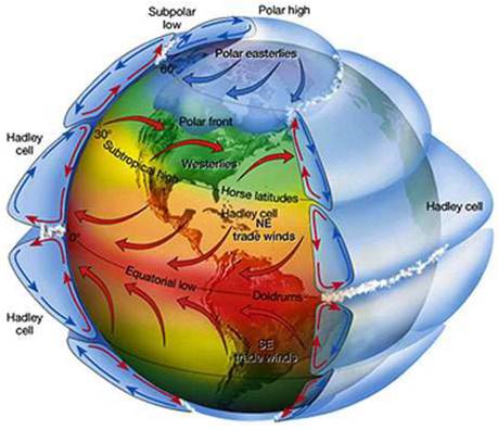
The pattern of planetary winds largely depends on:
- The rotation of earth.
- Emergence of pressure belts,
- Latitudinal variation of atmospheric heating,
- The migration of belts following apparent path of the sun,
- The distribution of continents and oceans.
The pattern of the movement of the planetary winds is called the general circulation of the atmosphere. The general circulation of the atmosphere also sets in motion the ocean water circulation which influences the earth’s climate (it is shown in Figure 10.6). The air at the Inter Tropical Convergence Zone (ITCZ) rises because of convection caused by high insolation and a low pressure is created.The converged air rises along with the convective cell.
It reaches the top of the troposphere up to an altitude of 14 km. and moves towards the poles. This causes accumulation of air at about 30 N and S. Down below near the land surface the air flows towards the equator as the easterlies.
- Cells : Such circulations from the surface upwards and vice-versa are called cells.
- Ferrel cell : At the surface these winds are called westerlies and the cell is known as the Ferrel cell.
- Polar cell : At polar latitudes the cold dense air subsides near the poles and blows towards middle latitudes as the polar easterlies. This cell is called the polar cell.
General Atmospheric Circulation and its Effects on Oceans :
Warming and cooling of the Pacific Ocean is most important in terms of general atmospheric circulation. The warm water of the central Pacific Ocean slowly drifts towards South American coast and replaces the cool Peruvian current. Such appearance of warm water off the coast of Peru is known as the El Nino. The El Nino event is closely associated with the pressure changes in the Central Pacific and Australia. This change in pressure condition over Pacific is known as the southern oscillation. The combined phenomenon of southern oscillation and El Nino is known as ENSO.
Its Effects on Oceans : In the years when the ENSO is strong, large-scale variations in weather occur over the world. The arid west coast of South America receives heavy rainfall, drought occurs in Australia and sometimes in India and floods in China.
Seasonal Winds : The pattern of wind circulation is modified indifferent seasons due to the shifting of regions of maximum heating, pressure and wind belts. The most pronounced effect of such a shift is noticed in the monsoons, especially over southeast Asia.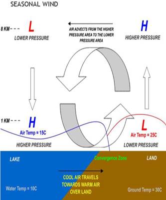
The other local deviations from the general circulation system are as follows.
Local Winds :
Differences in the heating and cooling of earth surfaces and the cycles those develop daily or annually can create several common, local or regional winds.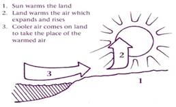
Land and Sea Breezes :
During the day the land heats up faster and becomes warmer than the sea. Therefore, over the land the air rises giving rise to a low pressure area, whereas the sea is relatively cool and the pressure over sea is relatively high. Thus, pressure gradient from sea to land is created and the wind blows from the sea to the land as the sea breeze. but, In the night the reversal of condition takes place. The land loses heat faster and is cooler than the sea. The pressure gradient is from the land to the sea and hence land breeze results (Figure 10.7).
Figure 10.7: Land and sea breezes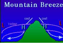
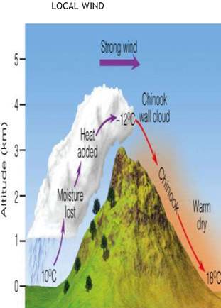
Mountain wind : During the night the slopes get cooled and the dense air descends into the valley as the mountain wind. The cool air, of the high plateaus and ice fields draining into the valley is called katabatic wind. Another type of warm wind occurs on the leeward side of the mountain ranges. The moisture in these winds, while crossing the mountain ranges condense and precipitate.
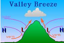
Valley breeze : In mountainous regions, during the day the slopes get heated up and air moves upslope and to fill the resulting gap the air from the valley blows up the valley. This wind is known as the valley breeze.
Air Mass :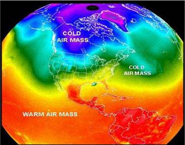
When the homogenous regions can be the vast ocean surface or vast plains. The air with distinctive characteristics in terms of temperature and humidity is called an air mass. It is defined as a large body of air having little horizontal variation in temperature and moisture. The homogenous surfaces, over which air masses form, are called the source regions.
The air masses are classified according to the source regions. There are five major source regions. These are:
- The relatively cold high latitude oceans,
- Warm tropical and subtropical oceans,
- The very cold snow covered continents in high latitudes,
- The subtropical hot deserts,
- Permanently ice covered continents in the Arctic and Antarctica.
These types of air masses are recognised:
- Maritime tropical (mT);
- Continental arctic (cA).
- Maritime polar (mP);
- Continental tropical (cT);
- Continental polar (cP);
- Tropical air masses are warm and polar air masses are cold.
Fronts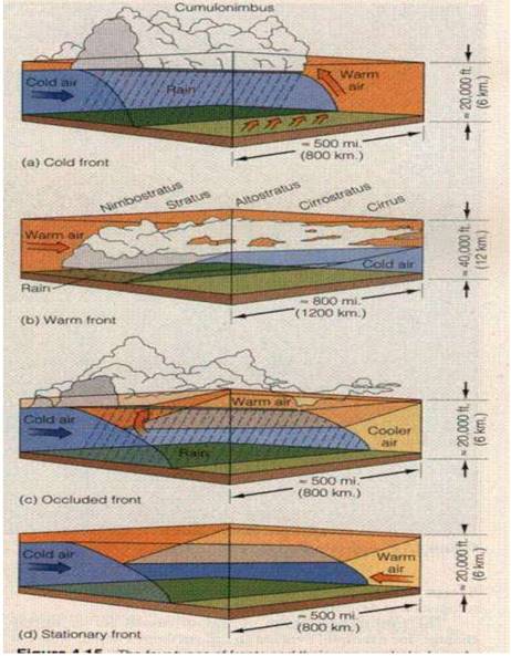
When two different air masses meet, the boundary zone between them is called a front.
The process of formation of the fronts is known as frontogenesis. There are four types of fronts:
- Cold;
- Warm;
- Stationary;
- Occluded.
When the front remains stationary, it is called a stationary front. When the cold air moves towards the warm air mass, its contact zone is called the cold front, whereas if the warm air mass moves towards the cold air mass, the contact zone is a warm front. If an air mass is fully lifted above the land surface, it is called the occluded front.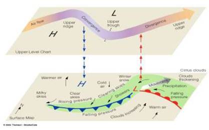
The fronts occur in middle latitudes and are characterized by steep gradient in temperature and pressure. They bring abrupt changes in temperature and cause the air to rise to form clouds and cause precipitation.
Extra Tropical Cyclones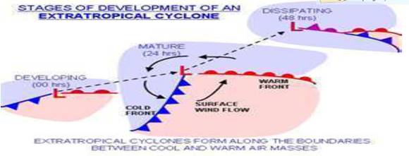
The system developing in the mid and high latitude, beyond the tropics are called the middle latitude or extra tropical cyclones.
location of temperate cyclones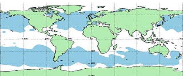
The passage of front causes abrupt changes in the weather conditions over the area in the middle and high latitudes. Extra tropical cyclones form along the polar front.
Initially, the front is stationary. In the northern hemisphere, warm air blows from the south and cold air from the north of the front.
When the pressure drops along the front, the warm air moves northwards and the cold air move towards, south setting in motion an anticlockwise cyclonic circulation.
The cyclonic circulation leads to a well developed extra tropical cyclone, with a warm front and a cold front.
Tropical Cyclones
Tropical cyclones are violent storms that originate over oceans in tropical areas and large scale destruction caused by violent winds, very heavy rainfall and storm surges. This is one of the most devastating natural calamities. They are known as Cyclones in the Indian Ocean, Hurricanes in the Atlantic, Typhoons in the Western Pacific and South China Sea, and Willy-willies in the Western Australia.
Tropical cyclones originate and intensify over warm tropical oceans.
The conditions favourable for the formation and intensification of tropical storms are:
- Large sea surface with temperature higher than 27°C;
- Presence of the Coriolis force;
- Small variations in the vertical wind speed;
- A pre-existing weak low-pressure area or low-level-cyclonic circulation;
- Upper divergence above the sea level system.
The energy that intensifies the storm, comes from the condensation process in the towering cumulonimbus clouds, surrounding the centre of the storm. With continuous supply of moisture from the sea, the storm is further strengthened. On reaching the land the moisture supply is cut off and the storm dissipates. The place where a tropical cyclone crosses the coast is called the landfall of the cyclone. The cyclones, which cross 20 N latitude generally, reserve and they are more destructive. A schematic representation of the vertical structure of a mature tropical cyclonic storm is shown in Figure given below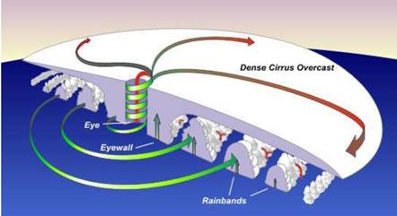
Physical Structure of Tropical Cyclone
To best understand the structure of tropical cyclones, you may find useful to briefly review the concept of thermal wind and vorticity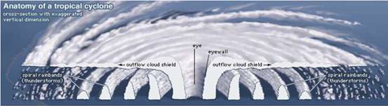
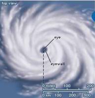
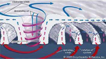
Structure of a tropical cyclone. (Source: Britannica) :
A mature tropical cyclone is characterized by the strong spirally circulating wind around the centre, called the eye. The diameter of the circulating system can vary between 150 and 250 km. The wind reaches maximum velocity in this region, reaching as high as 250 km per hour. Torrential rain occurs here. From the eye wall rain bands may radiate and trains of cumulus and cumulonimbus clouds may drift into the outer region. The diameter of the storm over the Bay of Bengal, Arabian sea and Indian ocean is between 600 - 1200 km. The system moves slowly about 300 - 500 km per day.
Thunderstones and Tornadoes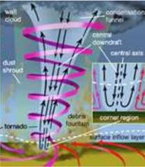
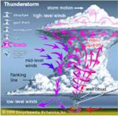
Other severe local storms are thunderstorms and tornadoes. They are of short duration, occurring over a small area but are violent. Thunderstorms are caused by intense convection on moist hot days. Such a phenomenon is called a tornado. Tornadoes generally occur in middle latitudes. The tornado over the sea is called water sprouts.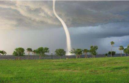
These violent storms are the manifestation of the atmosphere’s adjustments to varying energy distribution.
